(This is an archived page about the annular solar eclipse that occurred on October 14, 2023. For information on future eclipses, please see our Upcoming Eclipse Maps page.)
On October 14, 2023, an annular, or "ring of fire," solar eclipse will occur along a narrow path of annularity in Texas. To experience the annular, or "ring of fire," phase of the eclipse, you must be located within this path, with the duration of annularity lasting the longest at the centerline. But where along the path should you plan to go? Below, we've outlined some of the unique features, landmarks, and viewing options along the path of annularity for Texas. We've also provided detailed maps of the path of annularity in Texas as well as annularity start times and durations for Texas cities that are located inside the path of annularity on October 14, 2023.
Remember that you must use special eclipse safety glasses or viewers at all times during an annular, or "ring of fire," solar eclipse. The NationalEclipse.com Eclipse Store offers a wide variety of certified safe eclipse glasses and viewers.
Note that times and durations can vary widely even within the same city and some cities are located only partially within the path of annularity. All times and durations noted on this page are only representative samples and should be used for general comparison purposes only.
To avoid confusion, note that references made below to the "western" and "eastern" limits or lines of the eclipse refer respectively to the left/bottom and right/top edges of the eclipse path as it gradually changes its direction from east to south as it travels across the U.S.
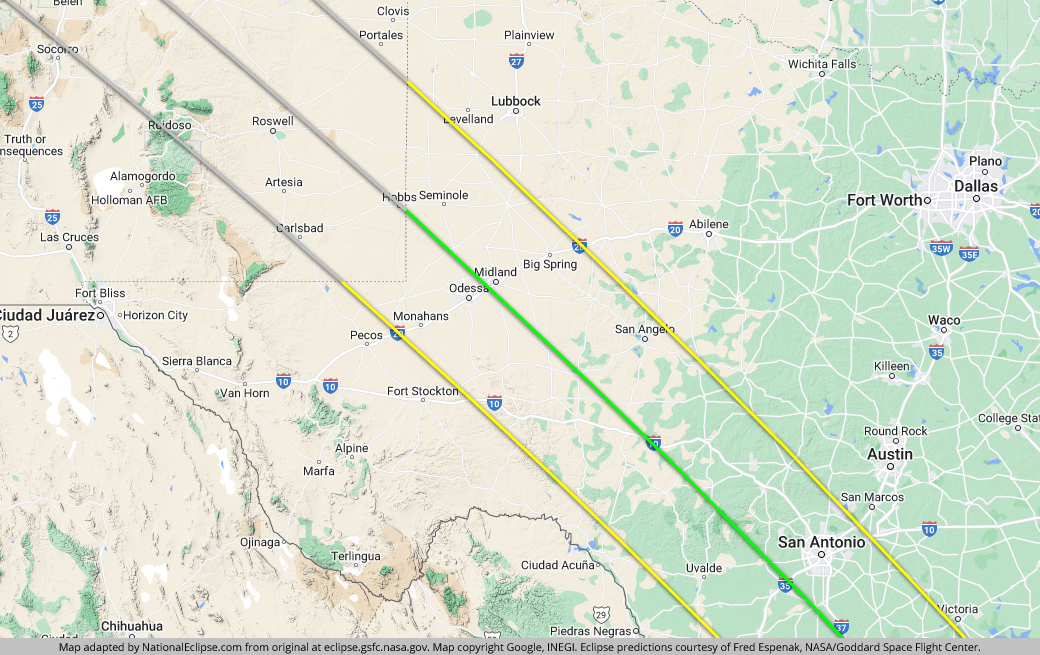
The centerline of the eclipse enters Texas at approximately 10:17am CDT, with annularity beginning in that location at about 11:41am CDT.
After entering the U.S. in Oregon and traveling approximately 1,375 miles along the centerline in about 25 minutes and 29 seconds at an average speed of 3,239 miles per hour, the Moon's shadow begins the last leg of its journey across America. And with a centerline track of 494 miles, this last leg in Texas is also the longest leg in America, accounting for more than a quarter of the path's total length in the United States.
Midland and Odessa straddle the east and west sides of the eclipse centerline, respectively. In downtown Odessa, annularity will last for about 4 minutes and 49 seconds. Not bad, but Midland is a tad closer to the centerline, with annularity lasting for about 4 minutes and 55 seconds downtown, just 7 seconds short of the maximum duration of annularity anywhere in the country.
Interstate 20 bisects the entire width of the path in Texas and links it with El Paso to the west and the Dallas/Forth Worth area to the east, both only a day trip away. From El Paso, annularity can be reached by taking Interstate 10 to I-20. From Dallas, I-20 will take you all the way to annularity. To the north, Lubbock is even closer. You can reach the path in less than an hour by driving south on U.S. Route 87.

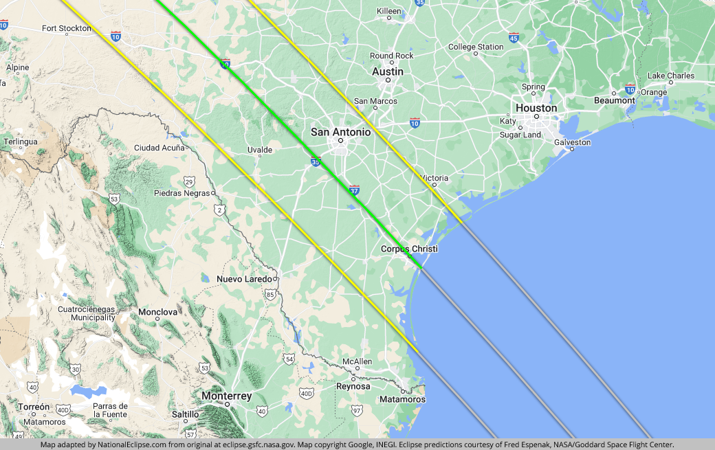
Farther along, the eclipse crosses over the largest city it will encounter along its journey through the United States. San Antonio is located about halfway between the centerline and the eastern limit of the eclipse path, with annularity lasting for about 4 minutes and 21 seconds downtown. In fact, it's important to note that all of San Antonio is located inside the 2023 eclipse path, which unfortunately is not the case six months later when only a portion of the city is captured inside the path of the total solar eclipse that will sweep across the U.S. on April 8, 2024. The lucky citizens of San Antonio will have a chance to experience two solar eclipses in the span of only six months, but only this annular solar eclipse on October 14, 2023, will cross over the heart of the city. To the west of San Antonio, a large diamond-shaped area in the Texas Hill Country is where the 2023 annular solar eclipse path overlaps with that of the 2024 total solar eclipse. The exact point where the centerlines cross is near the tiny town of Vanderpool.
Interstate 10 enters the eclipse path from the west before crossing the centerline and turning south to meet up with San Antonio. Interstate 35 crosses the entire width of the eclipse path, coming in from the south, crossing the centerline and San Antonio, and heading off toward Austin. In fact, Austin is so close to the eastern edge of the eclipse path that it can make an extremely convenient basecamp for eclipse chasers who prefer the fun of Austin over the fun of San Antonio. On eclipse day, it's a quick drive south on I-35 to reach the path. Houston is also relatively close on the east side. Drive west on I-10 to reach the path in less than three hours. Interstate 37 runs south from San Antonio down to the coast, tracing a path almost directly over the centerline. All of these interstate highways will make getting around this part of Texas easy on eclipse day, especially if cloudy skies requires a quick move to a different location.

The last major port of call for the eclipse in the U.S. is Corpus Christi. Since entering the U.S. in the Pacific Northwest, the eclipse's duration of annularity—or how long the Sun will appear as a perfect "ring of fire" in the sky—will have been steadily increasing, with the shortest durations on the Oregon coast and the longest durations here on the Gulf coast. What's more, the centerline of the eclipse—where durations last the longest in any one area—slices directly through the center of Corpus Christi. The result is a duration of annularity for this Gulf Coast city that cracks the 5-minute mark in some parts of town, including about 5 minutes and 2 seconds in the downtown area. These long durations make Corpus Christi a great eclipse-watching destination if you want the longest experience possible in the U.S. Just make sure to check short-term weather forecasts for the possibility of cloudiness along the shore during the late-morning hours. Obviously, a long duration of annularity is meaningless if you can't see the eclipse. The centerline last touches U.S. soil as it crosses over the city's barrier islands before heading out into the Gulf of Mexico, crossing through Central America and South America, and concluding its long journey in the Atlantic Ocean off the coast of Brazil.
The centerline of the eclipse exits the state, and the U.S., at approximately 1:38pm CDT, with annularity coming to an end in that location at about 12:01pm CDT. From the New Mexico-Texas border to the Gulf of Mexico, the Moon's shadow travels approximately 494 miles along the centerline in about 15 minutes and 1 second at an average speed of 1,972 miles per hour.
TOPFor the maps below, the yellow lines outline the limits of the path of annularity in Texas. The green middle line represents the eclipse centerline, where the annular, or "ring of fire," phase lasts the longest in Texas. The grey lines show the path of annularity entering and exiting Texas. To experience the annular, or "ring of fire," phase of the eclipse in Texas, you must be within the yellow lines. The closer you are to the green centerline, the longer annularity will last. Areas outside the path of annularity will get a non-annular partial solar eclipse only.
(hover or tap to see points of interest in Texas)
(hover or tap to see points of interest in Texas)
| City | Annularity Start | Duration* |
|---|---|---|
| Denver City | 11:41:36 AM CDT | 4:28 |
| Plains | 11:41:40 AM CDT | 3:54 |
| Seminole | 11:42:01 AM CDT | 4:39 |
| Seagraves | 11:42:12 AM CDT | 4:02 |
| Andrews | 11:42:25 AM CDT | 4:55 |
| Kermit | 11:42:46 AM CDT | 3:37 |
| West Odessa | 11:43:05 AM CDT | 4:42 |
| Wink | 11:43:09 AM CDT | 2:52 |
| Odessa | 11:43:13 AM CDT | 4:49 |
| Midland | 11:43:25 AM CDT | 4:55 |
| Monahans | 11:43:34 AM CDT | 3:09 |
| Brownfield | 11:43:41 AM CDT | 1:26 |
| Wickett | 11:43:45 AM CDT | 2:30 |
| Lamesa | 11:43:49 AM CDT | 2:57 |
| Stanton | 11:43:54 AM CDT | 4:31 |
| Crane | 11:44:06 AM CDT | 4:02 |
| Ackerly | 11:44:18 AM CDT | 3:05 |
| Garden City | 11:44:36 AM CDT | 4:33 |
| Rankin | 11:44:42 AM CDT | 4:25 |
| Big Spring | 11:44:44 AM CDT | 3:29 |
| Grandfalls | 11:44:46 AM CDT | 1:24 |
| McCamey | 11:44:52 AM CDT | 3:28 |
| Texon | 11:44:54 AM CDT | 4:45 |
| Big Lake | 11:45:12 AM CDT | 4:54 |
| Coahoma | 11:45:25 AM CDT | 2:30 |
| Iraan | 11:45:30 AM CDT | 3:38 |
| Barnhart | 11:45:40 AM CDT | 4:58 |
| Sterling City | 11:45:52 AM CDT | 3:32 |
| Mertzon | 11:46:11 AM CDT | 4:40 |
| Sheffield | 11:46:15 AM CDT | 2:52 |
| Ozona | 11:46:18 AM CDT | 4:35 |
| Eldorado | 11:46:51 AM CDT | 4:54 |
| Grape Creek | 11:47:03 AM CDT | 2:59 |
| Sonora | 11:47:06 AM CDT | 4:56 |
| San Angelo | 11:47:15 AM CDT | 3:11 |
| Wall | 11:47:36 AM CDT | 3:05 |
| Juno | 11:47:49 AM CDT | 3:05 |
| Rocksprings | 11:48:30 AM CDT | 4:49 |
| Junction | 11:48:45 AM CDT | 4:29 |
| Menard | 11:48:52 AM CDT | 3:10 |
| Carta Valley | 11:48:53 AM CDT | 3:10 |
| Eden | 11:49:27 AM CDT | 1:08 |
| Leakey | 11:49:29 AM CDT | 4:55 |
| Vanderpool | 11:49:45 AM CDT | 5:00 |
| Concan | 11:49:57 AM CDT | 4:42 |
| Utopia | 11:49:58 AM CDT | 4:58 |
| Ingram | 11:50:07 AM CDT | 4:23 |
| Harper | 11:50:08 AM CDT | 3:46 |
| Medina | 11:50:14 AM CDT | 4:51 |
| Tarpley | 11:50:18 AM CDT | 4:58 |
| Kerrville | 11:50:22 AM CDT | 4:15 |
| Uvalde | 11:50:37 AM CDT | 3:55 |
| Bandera | 11:50:38 AM CDT | 4:45 |
| Comfort | 11:51:01 AM CDT | 3:53 |
| Boerne | 11:51:29 AM CDT | 3:57 |
| Fredericksburg | 11:51:32 AM CDT | 2:11 |
| Pearsall | 11:51:45 AM CDT | 4:38 |
| San Antonio | 11:52:08 AM CDT | 4:21 |
| Dilley | 11:52:17 AM CDT | 3:56 |
| Pleasanton | 11:52:27 AM CDT | 4:58 |
| Spring Branch | 11:52:50 AM CDT | 2:00 |
| Floresville | 11:53:04 AM CDT | 4:20 |
| Cotulla | 11:53:09 AM CDT | 2:37 |
| Three Rivers | 11:53:36 AM CDT | 5:01 |
| Karnes City | 11:53:47 AM CDT | 4:22 |
| George West | 11:53:54 AM CDT | 5:00 |
| Kenedy | 11:53:56 AM CDT | 4:25 |
| New Braunfels | 11:54:02 AM CDT | 0:59 |
| Beeville | 11:54:26 AM CDT | 4:54 |
| Seguin | 11:54:37 AM CDT | 0:41 |
| Mathis | 11:54:41 AM CDT | 5:01 |
| Freer | 11:54:53 AM CDT | 2:40 |
| San Diego | 11:55:06 AM CDT | 3:46 |
| Alice | 11:55:10 AM CDT | 4:13 |
| Goliad | 11:55:18 AM CDT | 3:35 |
| Corpus Christi | 11:55:48 AM CDT | 5:02 |
| Kingsville | 11:55:55 AM CDT | 4:08 |
| Aransas Pass | 11:56:08 AM CDT | 4:51 |
| Rockport | 11:56:17 AM CDT | 4:32 |
| Port Aransas | 11:56:24 AM CDT | 4:50 |
| Riviera | 11:56:36 AM CDT | 3:31 |
* "Duration" refers to the duration of annularity and is expressed in minutes and seconds
TOP