(This is an archived page about the annular solar eclipse that occurred on October 14, 2023. For information on future eclipses, please see our Upcoming Eclipse Maps page.)
On October 14, 2023, an annular, or "ring of fire," solar eclipse will occur along a narrow path of annularity in Oregon. To experience the annular, or "ring of fire," phase of the eclipse, you must be located within this path, with the duration of annularity lasting the longest at the centerline. But where along the path should you plan to go? Below, we've outlined some of the unique features, landmarks, and viewing options along the path of annularity for Oregon. We've also provided a detailed map of the path of annularity in Oregon as well as annularity start times and durations for Oregon cities that are located inside the path of annularity on October 14, 2023.
Remember that you must use special eclipse safety glasses or viewers at all times during an annular, or "ring of fire," solar eclipse. The NationalEclipse.com Eclipse Store offers a wide variety of certified safe eclipse glasses and viewers.
Note that times and durations can vary widely even within the same city and some cities are located only partially within the path of annularity. All times and durations noted on this page are only representative samples and should be used for general comparison purposes only.
To avoid confusion, note that references made below to the "western" and "eastern" limits or lines of the eclipse refer respectively to the left/bottom and right/top edges of the eclipse path as it gradually changes its direction from east to south as it travels across the U.S.
The centerline of the eclipse enters the U.S. in Oregon at approximately 8:05am PDT, with annularity beginning in that location at about 9:15am PDT.
When it first touches U.S. soil on the coast of Oregon on Saturday morning, having been born out in the Pacific Ocean only about 5 minutes earlier, the eclipse will be very low in the sky. At only about five degrees above the horizon at the start of the partial phase and about 17 degrees during annularity, observers will need to find a location free of tall buildings, trees, and terrain in the direction of the Sun. Oregon's beaches will likely be a popular gathering spot within the 137-mile-wide path of annularity, but remember that the Sun will be rising in the east, not over the water. The maritime climate along the coast could also produce morning clouds and fog that might obscure the view.
Better weather might be found farther inland in the valleys beyond the Coast Range, but even there morning fog might be a problem and the Cascades to the east might obstruct a view of the rising Sun. Eugene is located between the centerline and the eastern limit of the eclipse path, with annularity lasting for about 3 minutes and 55 seconds in the downtown area. Interstate 5 crosses the entire width of the eclipse path between the Coast Range and the Cascades. Although Portland and Salem aren't located within the path of annularity, they're close enough to serve as convenient basecamps for viewing spots farther south along I-5.
The stunning Crater Lake National Park might be an appropriate place to view an eclipse (craters...Moon...get it?) and it's located relatively close to the centerline. If you decide to view the eclipse from here or anywhere else in the cloud-prone Cascades, make sure to check short-term weather forecasts in the days before the eclipse. Keep in mind, also, that it snows here in October.
Beyond the Cascades, the path of annularity descends down into Oregon's high desert, which promises a relatively good possibility of favorable eclipse-watching weather. Klamath Falls is located between the centerline and the western edge of the eclipse path, with annularity lasting for about 3 minutes and 23 seconds in the downtown area.
The centerline of the eclipse exits the state at approximately 10:44am PDT, with annularity coming to an end in that location at about 9:23am PDT. From the Pacific Ocean to the Oregon-Nevada border, the Moon's shadow travels approximately 276 miles along the centerline in 3 minutes and 18 seconds at an average speed of 5,025 miles per hour.
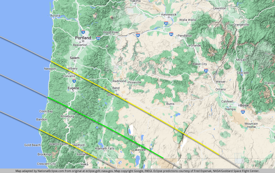
TOPFor the map below, the yellow lines outline the limits of the path of annularity in Oregon. The green middle line represents the eclipse centerline, where the annular, or "ring of fire," phase lasts the longest in Oregon. The grey lines show the path of annularity entering and exiting Oregon. To experience the annular, or "ring of fire," phase of the eclipse in Oregon, you must be within the yellow lines. The closer you are to the green centerline, the longer annularity will last. Areas outside the path of annularity will get a non-annular partial solar eclipse only.
(hover or tap to see points of interest in Oregon)
| City | Annularity Start | Duration* |
|---|---|---|
| Winchester Bay | 9:15:53 AM PDT | 4:31 |
| Reedsport | 9:15:55 AM PDT | 4:33 |
| Florence | 9:15:58 AM PDT | 4:32 |
| North Bend | 9:16:00 AM PDT | 4:08 |
| Coos Bay | 9:16:03 AM PDT | 4:03 |
| Yachats | 9:16:13 AM PDT | 4:09 |
| Coquille | 9:16:17 AM PDT | 3:34 |
| Bandon | 9:16:24 AM PDT | 3:01 |
| Sutherlin | 9:16:24 AM PDT | 4:32 |
| Roseburg | 9:16:27 AM PDT | 4:21 |
| Green | 9:16:29 AM PDT | 4:15 |
| Glide | 9:16:32 AM PDT | 4:32 |
| Veneta | 9:16:40 AM PDT | 4:08 |
| Cottage Grove | 9:16:42 AM PDT | 4:22 |
| Canyonville | 9:16:44 AM PDT | 3:49 |
| Newport | 9:16:49 AM PDT | 3:07 |
| Eugene | 9:16:57 AM PDT | 3:55 |
| Springfield | 9:17:01 AM PDT | 3:52 |
| Dexter | 9:17:04 AM PDT | 4:00 |
| Langlois | 9:17:06 AM PDT | 1:30 |
| Otter Rock | 9:17:07 AM PDT | 2:33 |
| Prospect | 9:17:07 AM PDT | 4:07 |
| Oakridge | 9:17:15 AM PDT | 4:05 |
| Depoe Bay | 9:17:20 AM PDT | 2:09 |
| Chemult | 9:17:28 AM PDT | 4:30 |
| Chiloquin | 9:17:29 AM PDT | 4:15 |
| Eagle Point | 9:17:35 AM PDT | 2:42 |
| Klamath Falls | 9:17:58 AM PDT | 3:23 |
| Bly | 9:17:59 AM PDT | 4:28 |
| Corvallis | 9:18:00 AM PDT | 1:45 |
| Bonanza | 9:18:02 AM PDT | 3:47 |
| Silver Lake | 9:18:07 AM PDT | 4:15 |
| Summer Lake | 9:18:16 AM PDT | 4:20 |
| Medford | 9:18:18 AM PDT | 1:10 |
| Paisley | 9:18:19 AM PDT | 4:33 |
| La Pine | 9:18:21 AM PDT | 3:12 |
| Fort Rock | 9:18:24 AM PDT | 3:42 |
| Lakeview | 9:18:27 AM PDT | 4:32 |
| Sweet Home | 9:18:28 AM PDT | 1:27 |
| Valley Falls | 9:18:28 AM PDT | 4:37 |
| New Pine Creek | 9:18:36 AM PDT | 4:20 |
| Christmas Valley | 9:18:43 AM PDT | 3:36 |
| Adel | 9:18:45 AM PDT | 4:38 |
| Plush | 9:18:47 AM PDT | 4:34 |
| Three Rivers | 9:18:50 AM PDT | 2:19 |
| Sunriver | 9:19:07 AM PDT | 1:48 |
| Fields | 9:20:01 AM PDT | 4:02 |
| Wagontire | 9:20:14 AM PDT | 1:45 |
| Andrews | 9:20:25 AM PDT | 3:19 |
| McDermitt | 9:21:02 AM PDT | 3:36 |
* "Duration" refers to the duration of annularity and is expressed in minutes and seconds
TOP