(This is an archived page about the annular solar eclipse that occurred on October 14, 2023. For information on future eclipses, please see our Upcoming Eclipse Maps page.)
On October 14, 2023, an annular, or "ring of fire," solar eclipse will occur along a narrow path of annularity in Nevada. To experience the annular, or "ring of fire," phase of the eclipse, you must be located within this path, with the duration of annularity lasting the longest at the centerline. But where along the path should you plan to go? Below, we've outlined some of the unique features, landmarks, and viewing options along the path of annularity for Nevada. We've also provided a detailed map of the path of annularity in Nevada as well as annularity start times and durations for Nevada cities that are located inside the path of annularity on October 14, 2023.
Remember that you must use special eclipse safety glasses or viewers at all times during an annular, or "ring of fire," solar eclipse. The NationalEclipse.com Eclipse Store offers a wide variety of certified safe eclipse glasses and viewers.
Note that times and durations can vary widely even within the same city and some cities are located only partially within the path of annularity. All times and durations noted on this page are only representative samples and should be used for general comparison purposes only.
To avoid confusion, note that references made below to the "western" and "eastern" limits or lines of the eclipse refer respectively to the left/bottom and right/top edges of the eclipse path as it gradually changes its direction from east to south as it travels across the U.S.
The centerline of the eclipse enters Nevada at approximately 8:06am PDT, with annularity beginning in that location at about 9:19am PDT.
The eclipse slices through most of northern Nevada, missing large cities like Las Vegas and Reno. Indeed, when it first enters the remote northwestern corner of the state, the path of annularity crosses miles and miles of barren desert containing little more than a few ghost towns and abandoned homesteads.
Farther east, the state becomes more populated, especially along Interstate 80. I-80 cuts across the entire width of the eclipse path in Nevada and will make getting to the centerline easy. Elko is located between the centerline and the eastern line of the eclipse path, with annularity lasting for about 4 minutes and 18 seconds in the downtown district of the city.
All throughout Nevada, the weather odds should be relatively favorable on eclipse day as the path of annularity travels the vast topography of arid mountain ranges and valleys known as the Great Basin. The chances of precipitation will be low and the chances for sunny skies should be relatively high, especially in the valleys.
To the west, Reno is less than two hours away from the eclipse path via I-80. To the east, Salt Lake City is also less than two hours away. From Salt Lake, I-80 will take you right up to the edge of the eclipse path and a quick jog down U.S. Route 93 Alt will take you into annularity and all the way to the centerline via the main spur of U.S. Route 93. Both cities can serve as convenient bases of operation for expeditions into the annularity zone on October 14.
Before leaving the state, the eclipse crosses over Great Basin National Park, including Wheeler Peak, the second-highest mountain in Nevada.
The centerline of the eclipse exits the state at approximately 10:53am PDT, with annularity coming to an end in that location at about 9:28am PDT. From the Oregon-Nevada border to the Nevada-Utah border, the Moon's shadow travels approximately 324 miles along the centerline in 5 minutes at an average speed of 3,888 miles per hour.
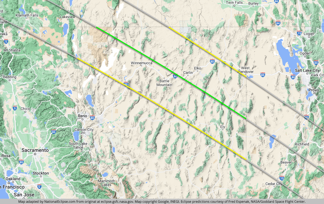
TOPFor the map below, the yellow lines outline the limits of the path of annularity in Nevada. The green middle line represents the eclipse centerline, where the annular, or "ring of fire," phase lasts the longest in Nevada. The grey lines show the path of annularity entering and exiting Nevada. To experience the annular, or "ring of fire," phase of the eclipse in Nevada, you must be within the yellow lines. The closer you are to the green centerline, the longer annularity will last. Areas outside the path of annularity will get a non-annular partial solar eclipse only.
(hover or tap to see points of interest in Nevada)
| City | Annularity Start | Duration* |
|---|---|---|
| Vya | 9:19:11 AM PDT | 3:51 |
| Denio | 9:19:50 AM PDT | 4:29 |
| Sulphur | 9:20:36 AM PDT | 2:57 |
| Platora | 9:20:37 AM PDT | 4:25 |
| Winnemucca | 9:20:40 AM PDT | 4:28 |
| Cordero | 9:20:46 AM PDT | 3:59 |
| Paradise Valley | 9:20:46 AM PDT | 4:31 |
| Golconda | 9:20:50 AM PDT | 4:34 |
| Imlay | 9:21:00 AM PDT | 3:10 |
| McDermitt | 9:21:01 AM PDT | 3:36 |
| Valmy | 9:21:10 AM PDT | 4:35 |
| Battle Mountain | 9:21:23 AM PDT | 4:31 |
| Beowawe | 9:21:43 AM PDT | 4:39 |
| Unionville | 9:21:43 AM PDT | 1:51 |
| Crescent Valley | 9:21:46 AM PDT | 4:27 |
| Carlin | 9:22:03 AM PDT | 4:38 |
| Tuscarora | 9:22:22 AM PDT | 3:37 |
| Jiggs | 9:22:28 AM PDT | 4:41 |
| Elko | 9:22:30 AM PDT | 4:18 |
| Shanty Town | 9:22:40 AM PDT | 4:41 |
| Spring Creek | 9:22:40 AM PDT | 4:20 |
| Ruby Valley | 9:22:41 AM PDT | 4:40 |
| Osino | 9:22:44 AM PDT | 3:58 |
| Lamoille | 9:22:48 AM PDT | 4:15 |
| Cherry Creek | 9:23:18 AM PDT | 4:42 |
| Currie | 9:23:29 AM PDT | 4:25 |
| Eureka | 9:23:33 AM PDT | 2:22 |
| McGill | 9:23:46 AM PDT | 4:14 |
| Ruth | 9:23:55 AM PDT | 3:35 |
| Ely | 9:23:59 AM PDT | 3:42 |
| Hamilton | 9:24:11 AM PDT | 2:08 |
| Baker | 9:24:35 AM PDT | 4:06 |
| Wells | 9:24:59 AM PDT | 0:41 |
* "Duration" refers to the duration of annularity and is expressed in minutes and seconds
TOP