(This is an archived page about the total solar eclipse that occurred on August 21, 2017. For information on future eclipses, please see our Upcoming Eclipse Maps page.)
On August 21, 2017, a total solar eclipse will carve a narrow path of totality from west to east across 12 U.S. states. To experience the total phase of the eclipse, you must be located within this narrow path of totality, with the duration of totality lasting the longest at the centerline. But where along the path should you plan to go? Below, we've outlined some of the unique features, landmarks, and viewing options along the path of totality for each state.
Remember that you must use special eclipse safety glasses or viewers at all times during the partial phases of a total solar eclipse. The NationalEclipse.com Eclipse Store offers a wide variety of certified safe eclipse glasses and viewers.
Note that times and durations can vary widely even within the same city and some cities are located only partially within the path of totality. All times and durations noted on this page are only representative samples and should be used for general comparison purposes only.
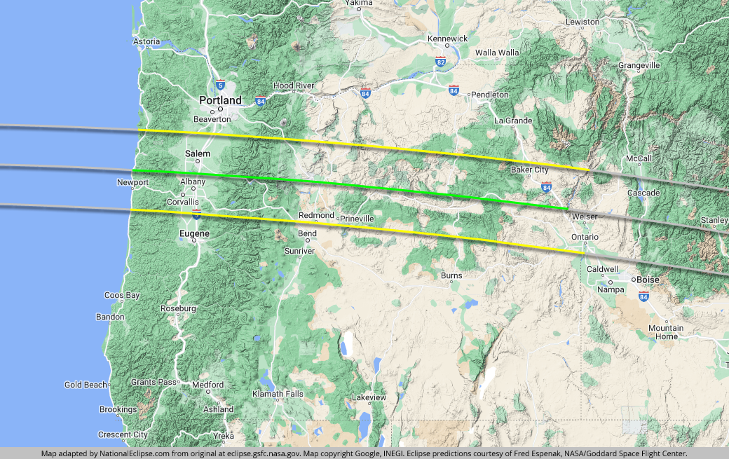
The centerline of the eclipse enters the U.S. in Oregon at approximately 9:04am PDT, with totality beginning in that location at about 10:15am PDT.
Although a coastal vantage point anywhere along the 62-mile-wide path of totality here would certainly make for a scenic eclipse experience, the maritime climate could produce morning clouds and fog that might spoil the event for observers. As an alternative, better weather is likely to be found farther inland in the Willamette Valley, where the eclipse crosses over Salem and Interstate 5. Salem is located between the centerline and the northern limit of the eclipse path, with totality lasting for about 1 minute and 54 seconds. If you're a baseball fan, you might enjoy attending Volcanoes EclipseFest, a three-game brewfest hosted by the Salem-Keizer Volcanoes that will culminate with a morning game on August 21 that will feature the first ever “eclipse delay” in baseball history. Although Portland isn't located within the path of totality, it's close enough to serve as a convenient basecamp for viewing spots farther south in the valley along I-5.
Another area that promises a good possibility of favorable weather is the area known as "The Basin" on the eastern side of the Cascades. In fact, eclipse weather forecasting site eclipsophile.com calls this area "perhaps the best anywhere in the United States." It's also here at the foot of the Cascades where the path of totality crosses the town of Madras. Madras will be home to the Oregon SolarFest, a week-long family-friendly festival at the Jefferson County Fairgrounds. Other viewing options include backtracking to the west and viewing the eclipse from Willamette National Forest—home to the second highest mountain in Oregon, Mount Jefferson—or even the Warm Springs Indian Reservation, through which the centerline travels.
Beyond Madras, the eclipse crosses over Ochoco National Forest, which will be the site of Oregon Eclipse 2017, a week-long "Global Eclipse Gathering" counter-culture festival. Northeast of the forest, the eclipse crosses over the three units of John Day Fossil Beds National Monument, which should offer some visually stunning panoramas for eclipse viewing.
Farther east in Oregon, the eclipse crosses over rugged terrain but Interstate 84 will provide easy access to viewing spots in the far eastern portion of the state, where the weather should be relatively favorable. One interesting option along I-84 is Baker City, which has the distinction of being the site where a U.S. Naval Observatory team observed the last coast-to-coast total solar eclipse in the U.S., in 1918. Baker City, however, is situated near the northern limit of the eclipse path and the duration of totality here will be over 30 seconds shorter than on the centerline in this area of the country.
The centerline of the eclipse exits the state as it crosses the Snake River at approximately 11:48am PDT, with totality coming to an end in that location at about 10:27am PDT. From the Pacific Ocean to the Oregon-Idaho border, the Moon's shadow travels approximately 337 miles along the centerline in 8 minutes and 59 seconds at an average speed of 2,252 miles per hour.
(hover or tap to see points of interest in Oregon)
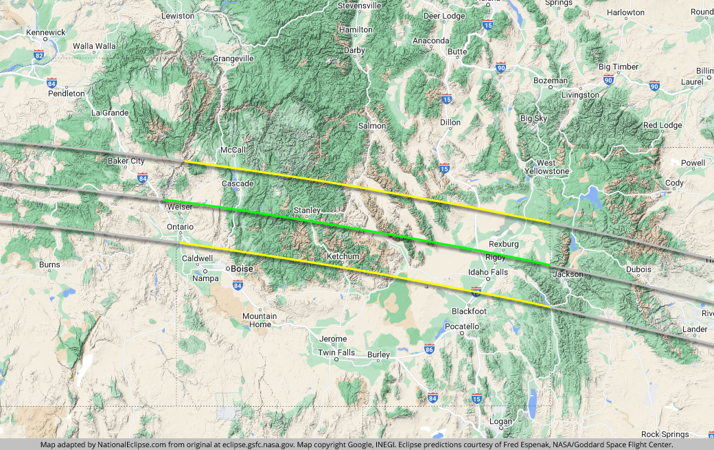
The centerline of the eclipse enters Idaho as it crosses the Snake River at approximately 10:10am MDT, with totality beginning in that location at about 11:24am MDT.
The weather prospects on the Idaho side of the Snake River seem promising (as they do on the Oregon side). But the path of totality soon ascends to much higher elevations in Boise National Forest, Salmon-Challis National Forest, and Sawtooth National Forest. All are beautiful wilderness areas, but difficult to access and prone to cloudiness. Boise isn't located within the path of totality, but it's very close on the southern side and will make a convenient basecamp for eclipse chasers.
On the other side of the mountains, the path of totality descends back down onto the Snake River Plain, which promises a good possibility of favorable weather. Idaho Falls is located between the centerline and the southern limit of the eclipse path, with totality lasting for about 1 minute and 48 seconds. Interstate 15 should provide easy access to many good viewing areas north of the city. Or, how about experiencing the shadow of the Moon in a place that purportedly looks like the Moon? The northern fringes of Craters of the Moon National Monument lie along the southern limit of the eclipse path, although the duration of totality will be relatively short here.
The centerline of the eclipse exits the state at approximately 12:59pm MDT, with totality coming to an end in that location at about 11:36am MDT. From the Oregon-Idaho border to the Idaho-Wyoming border, the Moon's shadow travels approximately 311 miles along the centerline in 9 minutes and 30 seconds at an average speed of 1,968 miles per hour.
(hover or tap to see points of interest in Idaho)
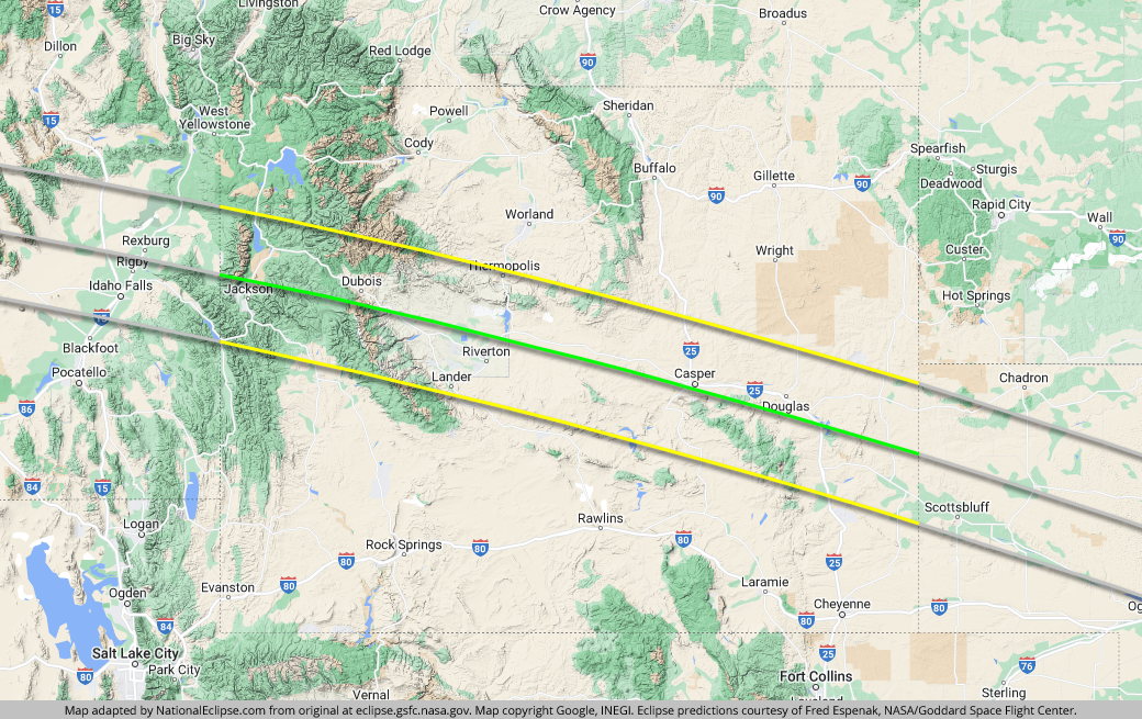
The centerline of the eclipse enters Wyoming at approximately 10:16am MDT, with totality beginning in that location at about 11:34am MDT.
Less than 30 seconds after entering the state, the centerline crosses the valley known as Jackson Hole. There's a good chance that there will also be a "hole" in the sky here, with any clouds restricted to the mountain peaks surrounding the valley. With the resort amenities and good weather prospects in Jackson Hole, the spectacular scenery inside Grand Teton National Park, and the proximity of Yellowstone National Park just to the north, this area will be a major viewing spot for the 2017 eclipse.
After Jackson Hole, the eclipse crosses over miles of mountain wilderness, but eventually descends back down to more hospitable terrain after crossing over the last significant elevation along the eclipse path until the Blue Ridge Mountains in Tennessee and North Carolina. It's here that the centerline cuts right through the center of the Wind River Indian Reservation. The reservation and surrounding areas should make for fine eclipse viewing. Much of the reservation is open to the public, but note that non-tribal visitors will need to purchase a permit to use public lands on the reservation.
Farther east in Wyoming, Casper sits virtually right on the centerline, with totality lasting for about 2 minutes and 26 seconds. Indeed, Casper will be a hotspot for the 2017 eclipse. In the days leading up to the eclipse, the Astronomical League will hold its annual national convention, ASTROCON, in Casper and the city is promoting an eclipse festival consisting of events and activities at various local-area institutions. Interstate 25 will make reaching these events easy from points both north and south.
The centerline of the eclipse exits the state at approximately 1:14pm MDT, with totality coming to an end in that location at about 11:49am MDT. From the Idaho-Wyoming border to the Wyoming-Nebraska border, the Moon's shadow travels approximately 365 miles along the centerline in 12 minutes and 29 seconds at an average speed of 1,754 miles per hour.
(hover or tap to see points of interest in Wyoming)
The centerline of the eclipse enters Nebraska at approximately 10:25am MDT, with totality beginning in that location at about 11:46am MDT.
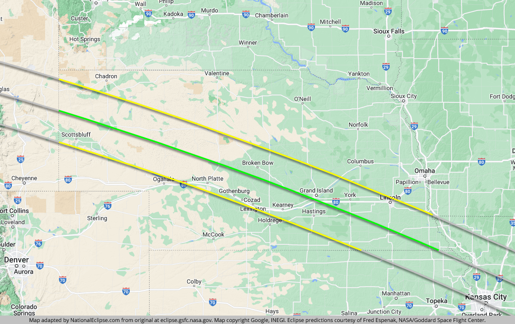
No other state can boast of a longer path of totality than Nebraska. With 467 miles of shadow coverage along the centerline, Nebraska's share of the path represents about 19 percent of the entire coast-to-coast mileage. And, indeed, no other state seems to include such a wide scattering of cities and towns planning to celebrate. From Gering and Alliance to Tryon and Stapleton to Dannebrog and Beatrice, Nebraskans are setting up viewing sites and planning eclipse-related events.
In western Nebraska, the path of totality crosses the town of Alliance, which is planning a weekend of activities at their local "Carhenge" attraction (think Stonehenge, but with vehicles) and other locations. Farther east, the eclipse crosses over North Platte, with totality lasting for about 1 minute and 45 seconds. Not bad, but not as good as what can be had in the towns of Tryon and Stapleton to the north, so North Platte is calling itself the "basecamp" for eclipse viewing in the Nebraska Sandhills and is partnering with Stapleton and Tryon.
The centerline skirts the southern fringes of Grand Island, where totality will last for about 2 minutes and 34 seconds, just 6 seconds less than the eclipse maximum. In Beatrice, Homestead National Monument of America is planning a weekend of activities at their National Park Service site. Nebraska's capital city, Lincoln, gets an invitation to the totality party, but the city is located along the northern limit of the eclipse path, with totality only lasting for about 1 minute and 25 seconds near the capitol building and dropping off quickly as you move north through the city, with a few areas just outside the path of totality. And while Omaha, Nebraska's largest city, isn't located within the path of totality, it's only about 37 miles away as the crow flies and will serve nicely as a source of overflow lodging.
Since the 2017 eclipse occurs in the summer, and since this is flat, wide-open Nebraska, the wise eclipse chaser will be wary of thunderstorms that may develop and will be ready to move to an alternate location if necessary. Interstate 80 runs from west to east within the eclipse path from North Platte to Grand Island to Lincoln, and on to Omaha, and will provide convenient access to other viewing sites if a quick change is needed.
The centerline of the eclipse exits the state at approximately 2:32pm CDT, with totality coming to an end in that location at about 1:07pm CDT. From the Wyoming-Nebraska border to the Nebraska-Kansas border, the Moon's shadow travels approximately 467 miles along the centerline in 17 minutes and 46 seconds at an average speed of 1,578 miles per hour.
(hover or tap to see points of interest in Nebraska)
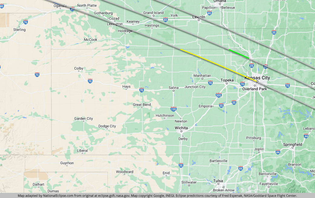
The centerline of the eclipse enters Kansas at approximately 11:39am CDT, with totality beginning in that location at about 1:04pm CDT.
The passage of the eclipse over Kansas seems almost like an afterthought, as it barely scrapes the northeastern corner of the state and the northern line of the path never even makes it into Kansas. Nevertheless, 36 other U.S. states see nothing of the path of totality, so residents of the Sunflower State should consider themselves lucky.
The path of totality crosses small towns and prairieland, along with the Kickapoo Indian Reservation, before it reaches the most populated area of its brief journey across the state: the Kansas side of Kansas City. Unfortunately, Kansas City, Kansas, is located along the southern limit of the eclipse path, with large parts of the city not even in the path, and the downtown area will get less than 30 seconds of totality. Luckily, the Kansas City, Kansas-Missouri, metropolitan area contains an extensive highway system that residents can use to access better viewing locations to the north.
The longest durations of totality in Kansas will be at viewing sites along the centerline, which belongs exclusively to Kansas for a 44-mile stretch that runs roughly parallel to the Missouri River in the extreme northeastern portion of the state. On the southern side of the eclipse path in Kansas, Topeka doesn't quite make the totality cut, but it's close enough to make a convenient base of operations for eclipse chasers.
The centerline of the eclipse exits the state as it crosses the Missouri River at approximately 2:34pm CDT, with totality coming to an end in that location at about 1:09pm CDT. From the Nebraska-Kansas border to the Kansas-Missouri border, the Moon's shadow travels approximately 44 miles along the centerline in 1 minute and 45 seconds at an average speed of 1,504 miles per hour.
(hover or tap to see points of interest in Kansas)
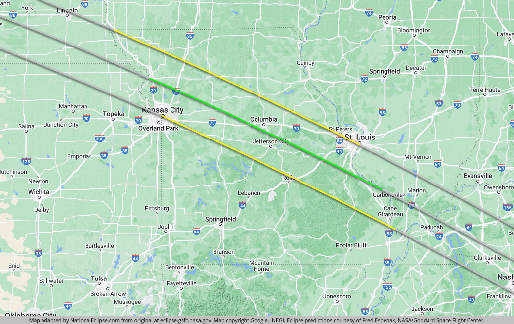
The centerline of the eclipse enters Missouri as it crosses the Missouri River at approximately 11:40am CDT, with totality beginning in that location at about 1:06pm CDT.
Only one other time along the length of its track does the centerline enter a state within the actual limits of a city or town, and the denizens of St. Joseph are getting ready to welcome the eclipse with open arms. At about 2 minutes and 38 seconds, the duration of totality here will be just 2 seconds short of the eclipse maximum.
South of St. Joseph, the southern line of the eclipse path cuts right through the center of Kansas City. If you're a resident of Kansas City, you either live in the path of totality or you don't. On August 21, 2017, the city will become top-heavy as floods of people position themselves in the northern part of town. To help orient yourself, the popular Power & Light District is just within the path, but totality will last for less than 30 seconds in this area. Interstates 29, 35, and 70 will help eclipse chasers in western Missouri get closer to the centerline for longer durations.
In the middle part of the state, the centerline comes close to Columbia, where totality will last for about 2 minutes and 37 seconds, just 3 seconds shy of the eclipse maximum. The Missouri state capital, Jefferson City, is close too, with totality lasting for around 2 minutes and 29 seconds.
As the eclipse continues to cut a southeasterly path across the state, its northern line cuts St. Louis in half. Much like Kansas City, St. Louis will be a tale of two cities on August 21. For example, if you're at the Gateway Arch, you'll only see a partial eclipse; if you're on a brewery tour at Anheuser-Busch, you'll see a total eclipse for about 19 seconds, give or take. For those who want to get out of St. Louis and get closer to the centerline for longer durations, Interstate 44 and Interstate 55 will get you there.
The centerline of the eclipse exits the state as it crosses the Mississippi River at approximately 2:46pm CDT, with totality coming to an end in that location at about 1:21pm CDT. From the Kansas-Missouri border to the Missouri-Illinois border, the Moon's shadow travels approximately 307 miles along the centerline in 12 minutes and 29 seconds at an average speed of 1,474 miles per hour.
(hover or tap to see points of interest in Missouri)
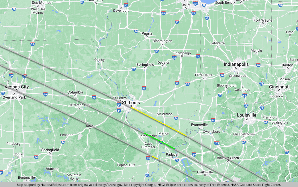
The centerline of the eclipse enters Illinois as it crosses the Mississippi River at approximately 11:51am CDT, with totality beginning in that location at about 1:18pm CDT.
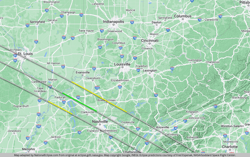
The path of the eclipse over Illinois is short, with the centerline traveling less than 100 miles, but Illinois will be the destination for many serious eclipse chasers for one important reason. About 37 miles after entering the state, the centerline reaches the "point of greatest duration" in the vicinity of Giant City State Park, near the town of Makanda. At no other point along the eclipse path will the duration of totality be longer than right here, at 2 minutes and 40.2 seconds. Of course, the difference is negligible for several miles in either direction along the centerline, so many eclipse viewers will set up camp in nearby Makanda, which the centerline travels directly through. In fact, you're only sacrificing a few seconds of totality by locating yourself on the centerline even hundreds of miles away, so unless you want to squeeze every fraction of a second out of your experience, you really don't need to be right here at the point of greatest duration. It's best to evaluate what's most important to you. Perhaps you don't mind sacrificing a few seconds of totality in order to see the eclipse from a location closer to your home or in an area with other attractions that you've always wanted to visit. Or maybe better weather odds in another part of the country is more important to you.
Wherever you choose to go, one thing is for sure. As the nearest city to the point of greatest duration, Carbondale will be packed with eclipse chasers on the big day. The duration of totality here will be about 2 minutes and 37 seconds, just 3 seconds short of the eclipse maximum reached on the centerline. August 21 is also the first day of classes at Southern Illinois University in Carbondale, and SIU is planning a public viewing from their football stadium and other fun. Incidentally, Carbondale and SIU are calling this area the “Eclipse Crossroads of America" because this also happens to be where the centerline of the 2017 eclipse crosses the centerline of the next total solar eclipse to occur in the U.S., on April 8, 2024.
Interstate 57 bisects the entire path of totality and comes within about 4 miles of the point of greatest duration. A bit farther east, Interstate 24 crosses the centerline before the eclipse heads into Shawnee National Forest, a great place to view the eclipse in a natural setting.
The centerline of the eclipse exits the state as it crosses the Ohio River at approximately 2:49pm CDT, with totality coming to an end in that location at about 1:24pm CDT. From the Missouri-Illinois border to the Illinois-Kentucky border, the Moon's shadow travels approximately 76 miles along the centerline in 3 minutes and 8 seconds at an average speed of 1,451 miles per hour.
(hover or tap to see points of interest in Illinois)
The centerline of the eclipse enters Kentucky as it crosses the Ohio River at approximately 11:54am CDT, with totality beginning in that location at about 1:22pm CDT.
The centerline will arrive in Kentucky having reached the "point of greatest duration" in Illinois, but there's an equally big draw for serious eclipse chasers here in the Bluegrass State, too. About 51 miles after entering the state, the centerline reaches the "point of greatest eclipse" in the vicinity of the unincorporated community of Cerulean. Simply put, the point of greatest eclipse is where the Moon's shadow aligns most closely with the Earth. It's really a technical distinction more than anything else, and totality won't appear any different here than it will anywhere else in the country. If nothing else, eclipse chasers will come here simply for the bragging rights. However, for most eclipses, the duration of totality at the point of greatest eclipse will be very close to the maximum duration reached at the official point of greatest duration, and in this case the two points differ by only a tenth of a second. If you do decide to see the eclipse from this location on the centerline, you'll enjoy virtually the longest duration of totality in the country and you can tell your friends that you witnessed the spectacle from the point of greatest eclipse. Is it worth it? It depends on what's most important to you. If you're not interested in technical distinctions and you don't mind sacrificing a few seconds of totality, there might be other locations along the path of totality elsewhere in the country that are easier to reach, more appealing, or less prone to clouds.
The largest city near the point of greatest eclipse is Hopkinsville, so plenty of eclipse chasers who do care about technical distinctions, or just don't know any better, will choose this locale as their home base. The duration of totality in Hopkinsville will max out at about 2 minutes and 40 seconds, just about the same as the eclipse maximum. In fact, due to their respective distances from the centerline, you'll actually experience a very slightly longer duration of totality in Hopkinsville than you will in Carbondale, the largest city near the official point of greatest duration in Illinois.
To the south and west of Hopkinsville, the path of totality crosses a wonderful place to see the eclipse in a natural setting. Land Between the Lakes National Recreation Area straddles almost the entire width of the path of totality between the centerline and the southern limit of the eclipse path. West of here, Paducah sits about halfway between the centerline and the southern limit of the eclipse path, with totality lasting for about 2 minutes and 21 seconds. Interstate 24 covers the entire length of the eclipse path in Kentucky and Interstate 69 crosses the centerline. Farther east, Bowling Green is located along the northern limit of the eclipse path, with totality only lasting for about 55 seconds on the campus of Western Kentucky University. The duration drops off steadily as you go north and east through town and some areas are outside the path altogether. From Bowling Green, use Interstate 65 to travel south and into Tennessee to get closer to the centerline and longer durations.
One other point of interest in Kentucky warrants a mention. Every year, the unincorporated community of Kelly holds an event called the "Little Green Men" Days Festival. The festival commemorates a local encounter with supposed extraterrestrials, known as the Hopkinsville Goblins, that took place on August 21, 1955. Notice the date? The close encounter occurred on the exact date of the upcoming eclipse, 62 years before. And the site of the farmhouse where the encounter occurred, just outside Hopkinsville, just happens to be mere miles from the point of greatest eclipse. Coincidence? Or are the Hopkinsville Goblins coming back on August 21, 2017? Some think they are. If you attend the "Little Green Men" Days Festival, you might just find out.
The centerline of the eclipse exits the state at approximately 2:52pm CDT, with totality coming to an end in that location at about 1:28pm CDT. From the Illinois-Kentucky border to the Kentucky-Tennessee border, the Moon's shadow travels approximately 98 miles along the centerline in 4 minutes and 5 seconds at an average speed of 1,447 miles per hour.
(hover or tap to see points of interest in Kentucky)
The centerline of the eclipse enters Tennessee at approximately 11:57am CDT, with totality beginning in that location at about 1:26pm CDT.
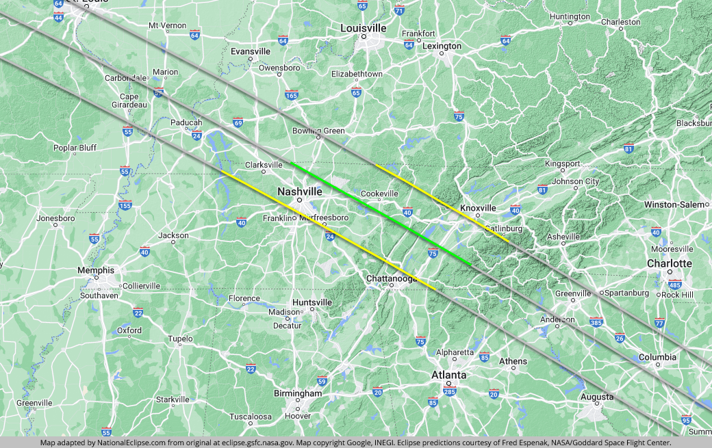
In Tennessee, the eclipse crosses over Nashville, the largest city it will encounter in its coast-to-coast journey. Music City is situated along the southern limit of the eclipse path with totality lasting for about 1 minute and 57 seconds at Nissan Stadium, for example, and durations progressively decreasing as you move in a southerly direction. Some areas within the Nashville city lines are just outside the path of totality. But the city itself and its wealth of lodging options are part of what will attract people to this particular location. Besides, the extensive highway system, including interstates 24, 40, and 65, will provide easy access on eclipse day to viewing sites closer to the centerline.
Farther east in Tennessee, the path of totality slowly ascends until it reaches the Blue Ridge Mountains near the Tennessee-North Carolina border, the first area of major elevation since Wyoming. The northern portion of the eclipse path enters Great Smoky Mountains National Park; the southern portion enters Cherokee National Forest. Either of these wilderness areas along the Tennessee-North Carolina border should make for scenic eclipse viewing but make sure you pick a location where trees won't restrict your view of the sky. If you position yourself up high, such as on a ridgeline or peak, you might even be able to see the shadow of the Moon as it speeds toward you across the landscape from the northwest. If you do decide that this is the place for you, keep a close eye on short-term weather forecasts for the region. Most weather experts indicate that the Blue Ridge Mountains are the area most prone to cloudiness along the entire eclipse track.
Although Chattanooga isn't located within the path of totality, it's close enough on the southern side to serve as a convenient basecamp for viewing spots in eastern Tennessee. On the northern side, Knoxville is even closer to the path. Interstate 75 connects both cities and crosses the entire width of the path.
The centerline of the eclipse exits the state at approximately 3:59pm EDT, with totality coming to an end in that location at about 2:36pm EDT. From the Kentucky-Tennessee border to the Tennessee-North Carolina border, the Moon's shadow travels approximately 186 miles along the centerline in 7 minutes and 44 seconds at an average speed of 1,445 miles per hour.
(hover or tap to see points of interest in Tennessee)
The centerline of the eclipse enters North Carolina at approximately 1:05pm EDT, with totality beginning in that location at about 2:33pm EDT.
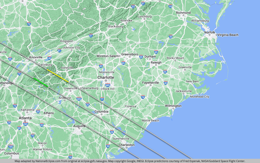
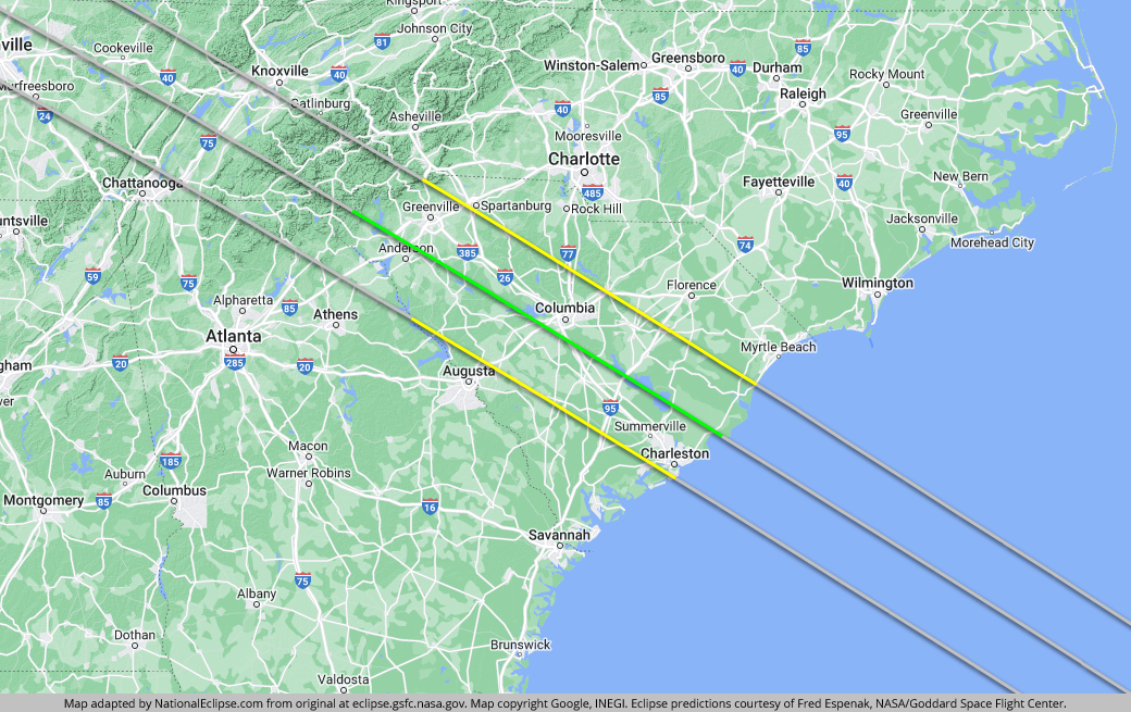
As it travels through a small section of the far western portion of the state, the path of totality misses any areas of significant population, never crossing a town with at least 10,000 people. The most populated town over which the eclipse travels in North Carolina is probably Cullowhee, where totality will last for about 1 minute and 54 seconds.
It's almost all mountain and forest here in this small corner of the state, which means a lot of natural settings in which to see the eclipse if you can find a clear view of the sky free of trees. Most of the eclipse path lies within Nantahala National Forest and a portion of Great Smoky Mountains National Park lies along the northern limit of the path. Clingman's Dome and its observation tower, at 6,643 feet the highest point within the path of totality in the eastern U.S., will be a popular place on eclipse day, although it's been announced that the site will be open only to ticketed guests and passes have already sold out.
The centerline only covers about 44 miles of territory here in North Carolina, and this is rugged terrain, so prime eclipse viewing spots are relatively limited. Your best bet in North Carolina might be the town of Andrews. Since the centerline crosses almost directly through Andrews, totality will last for about 2 minutes and 38 seconds, just 2 seconds less than the eclipse maximum. The potential for clouds could also be a problem here in the mountains, so be prepared to relocate to lower elevations if the short-term weather forecast calls for cloudy conditions. Although there aren't any large cities or towns located within the eclipse path itself in this part of North Carolina, Asheville is close by on the northern side of the path.
The centerline of the eclipse exits the state at approximately 4:01pm EDT, with totality coming to an end in that location at about 2:38pm EDT. From the Tennessee-North Carolina border to the North Carolina-Georgia border, the Moon's shadow travels approximately 44 miles along the centerline in 1 minute and 48 seconds at an average speed of 1,448 miles per hour.
(hover or tap to see points of interest in North Carolina)
The centerline of the eclipse enters Georgia at approximately 1:06pm EDT, with totality beginning in that location at about 2:35pm EDT.
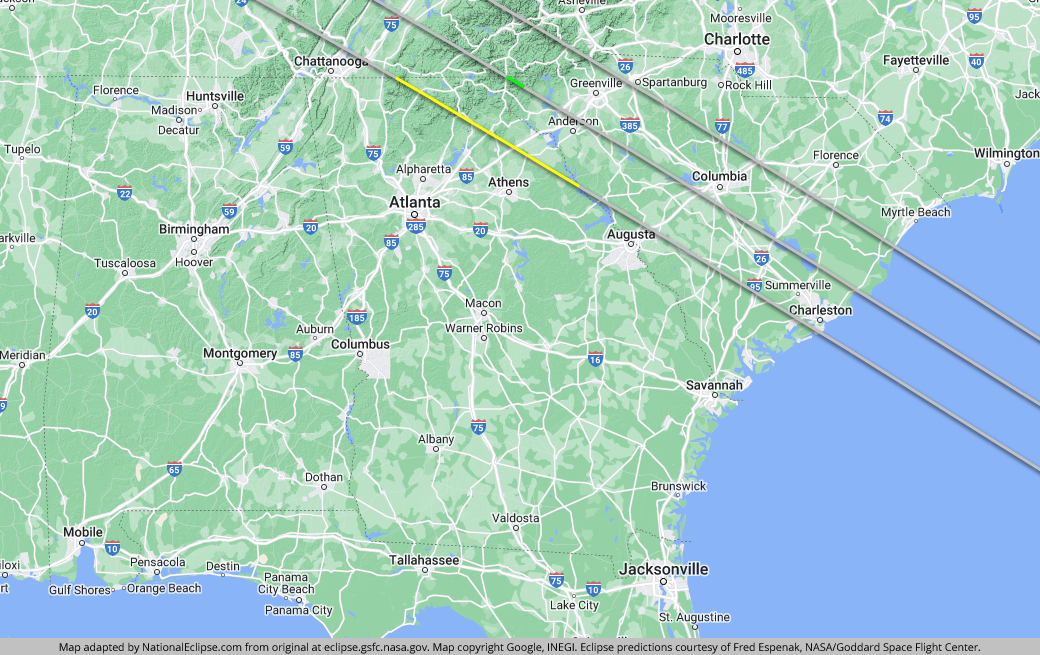
The centerline travels a mere 12 miles in Georgia, the shortest distance it will cover in any state. The northern line of the path never even makes it into the state, while the southern line cuts a more respectable 134-mile-long track across the northeastern corner of the state. As is the case with North Carolina to the north, the path of totality never crosses any town in Georgia with a population of at least 10,000. The largest town within the path is probably Toccoa, where totality will last for about 2 minutes.
Much of the eclipse path falls within Chattahoochee National Forest, and the centerline runs through the forest exclusively. If you can find a viewing site close to the centerline, you'll enjoy a scenic eclipse experience. However, there aren't many places to set up camp along the 12-mile centerline, and it's crossed by roads only two times in Georgia, but the towns of Sky Valley and Dillard and the unincorporated community of Pine Mountain are close. No, Atlanta isn't located within the path of totality, but it's not too far away. Since there won't be many lodging options in the sparsely populated area of Georgia through which the eclipse travels, Atlanta can serve as a relatively convenient basecamp. If you take Interstate 85 north from Atlanta, you'll end up in the path in less than two hours; keep going, and you'll arrive at the centerline in South Carolina.
The centerline of the eclipse exits the state as it crosses the Chattooga River at approximately 4:01pm EDT, with totality coming to an end in that location at about 2:38pm EDT. From the North Carolina-Georgia border to the Georgia-South Carolina border, the Moon's shadow travels approximately 12 miles along the centerline in 30 seconds at an average speed of 1,489 miles per hour.
(hover or tap to see points of interest in Georgia)
The centerline of the eclipse enters South Carolina as it crosses the Chattooga River at approximately 1:07pm EDT, with totality beginning in that location at about 2:36pm EDT.
After entering the U.S. in Oregon and traveling approximately 2,247 miles along the centerline in 80 minutes and 13 seconds at an average speed of 1,681 miles per hour, the Moon's shadow begins the last leg of its coast-to-coast journey across America. And with South Carolina being the state along the eclipse path most accessible to the massive population center on the Eastern Seaboard of the U.S., this last leg will arguably be where the greatest number of people witness nature's grandest spectacle.
Almost as soon as the path of totality enters South Carolina, it descends down from the Blue Ridge Mountains and onto increasingly flatter terrain for the remainder of its trip to the coast. Greenville is located about halfway between the centerline and the northern limit of the eclipse path, with totality lasting for about 2 minutes and 10 seconds. Interstate 85 crosses the entire width of the path and connects Greenville to the centerline. Farther east, Interstate 20 does the same for Columbia, the state capital and largest city in South Carolina, where totality will last for about 2 minutes and 30 seconds.
Interstate 26 runs parallel to the centerline through almost the entire state, providing access to plenty of good viewing areas. Dropping down from the northern limit of the path above Greenville, I-26 travels through Sumter National Forest, crosses Columbia and the centerline, and ends up in Charleston, the last major city along the path of totality. Charleston is situated along the southern limit of the eclipse path, so totality will last for a more modest duration here, about 1 minute and 31 seconds at Charleston's Battery Park. As you go west and south and get closer to the edge of the path, totality duration decreases quickly and a few Charleston neighborhoods are outside of the path. But from a weather standpoint, it's here along the coast, either in Charleston or farther north, where the risk of eclipse-time clouds may be the lowest in the state thanks to sea breezes that will help to move any clouds inland. And the coastal vantage point will make for a picturesque eclipse experience.
Interstate 95, the most important north-south corridor on the East Coast of the U.S., crosses the entire width of the path and will make the eclipse accessible to thousands of people traveling up and down the Atlantic Seaboard. As for the centerline, it intersects I-95 at Lake Marion and continues on to cut straight across Lake Moultrie and Francis Marion National Forest. The centerline last touches U.S. soil in Cape Romain National Wildlife Refuge before heading out into the Atlantic Ocean and concluding its journey off the coast of Africa.
The centerline of the eclipse exits the state, and the U.S., at approximately 4:10pm EDT, with totality coming to an end in that location at about 2:49pm EDT. From the Georgia-South Carolina border to the Atlantic Ocean, the Moon's shadow travels approximately 251 miles along the centerline in 10 minutes and 17 seconds at an average speed of 1,464 miles per hour.
(hover or tap to see points of interest in South Carolina)
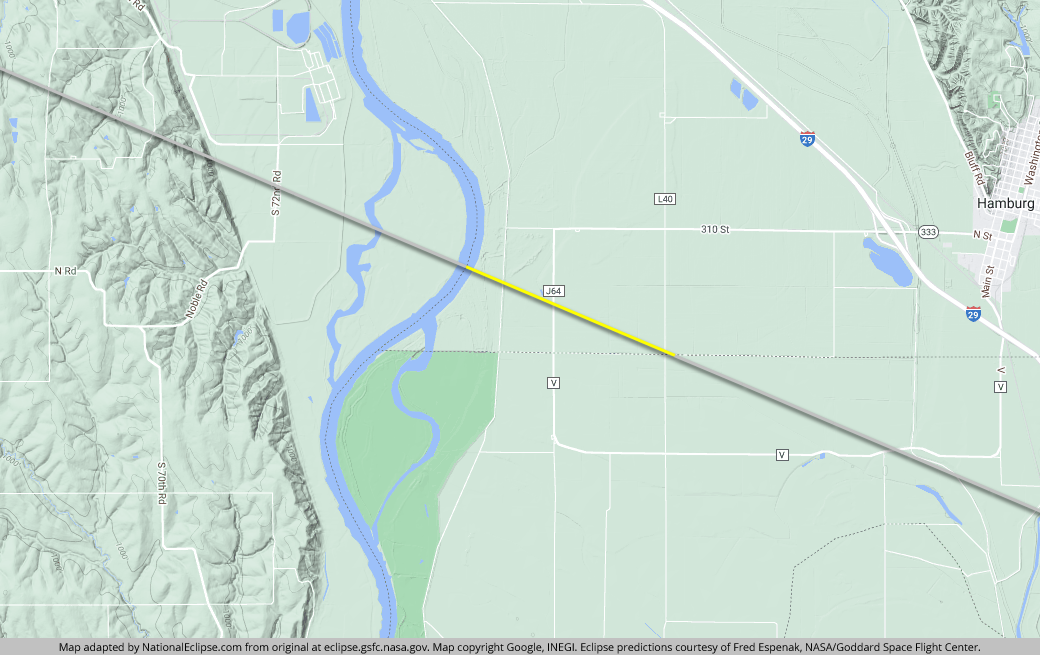
The eclipse crosses over tiny portions of two additional states on August 21, 2017. As it travels through eastern Idaho, the northern line of the eclipse path enters Montana for a quick journey of less than 4 miles before entering back into Idaho again. Farther east, as it crosses the Missouri River and exits Nebraska, the northern line makes a short detour into Iowa for less than 2 miles before entering Missouri.
(hover or tap to see details)
(hover or tap to see details)