(This is an archived page about the total solar eclipse that occurred on April 8, 2024. For information on future eclipses, please see our Upcoming Eclipse Maps page.)
On April 8, 2024, a total solar eclipse will occur along a narrow path of totality in Oklahoma. To experience the total phase of the eclipse, you must be located within this path, with the duration of totality lasting the longest at the centerline. But where along the path should you plan to go? Below, we've outlined some of the unique features, landmarks, and viewing options along the path of totality for Oklahoma. We've also provided a detailed map of the path of totality in Oklahoma as well as totality start times and durations for Oklahoma cities that are located inside the path of totality on April 8, 2024.
Remember that you must use special eclipse safety glasses or viewers at all times during the partial phases of a total solar eclipse. The NationalEclipse.com Eclipse Store offers a wide variety of certified safe eclipse glasses and viewers.
Note that times and durations can vary widely even within the same city and some cities are located only partially within the path of totality. All times and durations noted on this page are only representative samples and should be used for general comparison purposes only.
To avoid confusion, note that references made below to the "western" and "eastern" limits or lines of the eclipse refer respectively to the left/top and right/bottom edges of the eclipse path as it gradually changes its direction from north to east as it travels across the U.S.
The centerline of the eclipse enters Oklahoma as it crosses the Red River at approximately 12:27pm CDT, with totality beginning in that location at about 1:45pm CDT.
The path of the eclipse through Oklahoma is a relatively brief affair as it skims the southeastern corner of the state. The centerline travels through Oklahoma for a mere 31 miles, the shortest distance of any state through which the centerline travels, and the eastern line of the eclipse path never even makes it into the state.
In Oklahoma, the path never crosses a town with a population of at least 10,000 people. The most populated town over which the eclipse travels in Oklahoma is probably Poteau. Poteau, however, sits right along the western edge of the path, with totality lasting for only about 1 minute and 22 seconds in the middle of town. Durations drop off quickly as you go north and west and some northern neighborhoods are outside the path of totality.
Although Oklahoma City is well outside the eclipse path, you can easily reach totality with a day trip to the south or east. Driving south on Interstate 35 will get you to the path of totality in Texas while driving east on Interstate 40 will get you to totality in Arkansas.
The centerline of the eclipse exits the state at approximately 3:07pm CDT, with totality coming to an end in that location at about 1:50pm CDT. From the Texas-Oklahoma border to the Oklahoma-Arkansas border, the Moon's shadow travels approximately 31 miles along the centerline in 1 minute and 5 seconds at an average speed of 1,719 miles per hour.
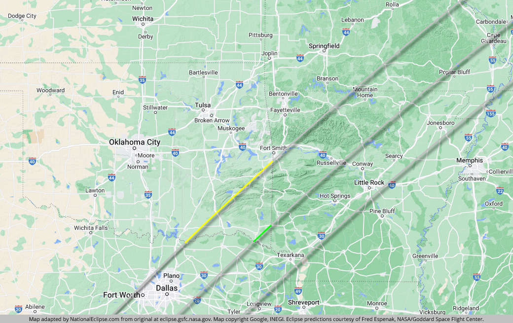
TOPFor the map below, the yellow line outlines the limits of the path of totality in Oklahoma. The green middle line represents the eclipse centerline, where totality lasts the longest in Oklahoma. The grey lines show the path of totality entering and exiting Oklahoma (the eastern line of the path doesn't enter Oklahoma). To experience the total phase of the eclipse in Oklahoma, you must be inside the yellow line. The closer you are to the green centerline, the longer totality will last. Areas outside the path of totality will get a partial solar eclipse only.
(hover or tap to see points of interest in Oklahoma)
| City | Totality Start | Duration* |
|---|---|---|
| Hugo | 1:44:55 PM CDT | 3:20 |
| Boswell | 1:45:03 PM CDT | 1:59 |
| Fort Towson | 1:45:06 PM CDT | 3:47 |
| Valliant | 1:45:14 PM CDT | 4:03 |
| Idabel | 1:45:23 PM CDT | 4:19 |
| Sobol | 1:45:30 PM CDT | 3:30 |
| Tom | 1:45:36 PM CDT | 4:13 |
| Broken Bow | 1:45:44 PM CDT | 4:17 |
| Antlers | 1:45:46 PM CDT | 1:56 |
| Talihina | 1:47:49 PM CDT | 1:09 |
| Wister | 1:48:29 PM CDT | 1:28 |
| Poteau | 1:48:49 PM CDT | 1:22 |
* "Duration" refers to the duration of totality and is expressed in minutes and seconds
TOP