(This is an archived page about the total solar eclipse that occurred on April 8, 2024. For information on future eclipses, please see our Upcoming Eclipse Maps page.)
On April 8, 2024, a total solar eclipse will occur along a narrow path of totality in Maine. To experience the total phase of the eclipse, you must be located within this path, with the duration of totality lasting the longest at the centerline. But where along the path should you plan to go? Below, we've outlined some of the unique features, landmarks, and viewing options along the path of totality for Maine. We've also provided a detailed map of the path of totality in Maine as well as totality start times and durations for Maine cities that are located inside the path of totality on April 8, 2024.
Remember that you must use special eclipse safety glasses or viewers at all times during the partial phases of a total solar eclipse. The NationalEclipse.com Eclipse Store offers a wide variety of certified safe eclipse glasses and viewers.
Note that times and durations can vary widely even within the same city and some cities are located only partially within the path of totality. All times and durations noted on this page are only representative samples and should be used for general comparison purposes only.
To avoid confusion, note that references made below to the "western" and "eastern" limits or lines of the eclipse refer respectively to the left/top and right/bottom edges of the eclipse path as it gradually changes its direction from north to east as it travels across the U.S.
The centerline of the eclipse enters Maine at approximately 2:18pm EDT, with totality beginning in that location at about 3:29pm EDT.
After entering the U.S. in Texas and traveling approximately 1,894 miles along the centerline in about 59 minutes and 10 seconds at an average speed of 1,920 miles per hour, the Moon's shadow begins the last leg of its journey across America. Indeed, as if on cue to celebrate this homestretch in the U.S., the centerline re-enters the States after a brief foray into Canada. In fact, Maine even reaches up to intercept the western line of the eclipse path, which ditched the U.S. for Canada way back in Ohio. For the first time in over 700 miles, the entire path of totality once again belongs exclusively to the United States. The downside, though, is that this stretch of eclipse track is perhaps the most prone to cloudy conditions in the entire U.S.

The path travels through the dense western forests of Maine, arguably the most remote region of land along the entire eclipse track in the U.S. It's endless miles of wilderness in these hinterlands with few signs of civilization. The centerline crosses almost directly over Mount Katahdin, the tallest mountain in Maine and the northern terminus of the famous Appalachian Trail. Farther east, more towns are peppered across the path, but as was the case in New Hampshire, the path never crosses a town with a population of at least 10,000 people. The largest town within the path is probably Presque Isle, along the eastern border with Canada, where totality will last for about 2 minutes and 49 seconds in the middle of town.
Interstate 95 crosses into the path of totality as it comes up from downstate Maine and it approaches the centerline before veering off to the east. The centerline itself last touches U.S. soil at the border with New Brunswick before heading out into Canada's Maritime provinces and Newfoundland before concluding its journey in the Atlantic Ocean.
The centerline of the eclipse exits the state, and the U.S., as it crosses the U.S.-Canada border at approximately 4:41pm EDT, with totality coming to an end in that location at about 3:35pm EDT. From the Québec-Maine border to the Maine-New Brunswick border, the Moon's shadow travels approximately 148 miles along the centerline in 3 minutes and 6 seconds at an average speed of 2,868 miles per hour.
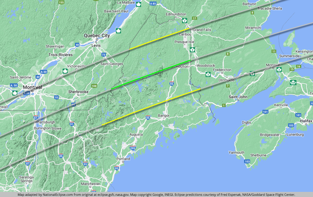
TOPFor the map below, the yellow lines outline the limits of the path of totality in Maine. The green middle line represents the eclipse centerline, where totality lasts the longest in Maine. The grey lines show the path of totality entering and exiting Maine. To experience the total phase of the eclipse in Maine, you must be within the yellow lines. The closer you are to the green centerline, the longer totality will last. Areas outside the path of totality will get a partial solar eclipse only.
(hover or tap to see points of interest in Maine)
| City | Totality Start | Duration* |
|---|---|---|
| Jackman | 3:29:30 PM EDT | 3:26 |
| Rangeley | 3:29:32 PM EDT | 2:24 |
| West Forks | 3:29:55 PM EDT | 3:06 |
| Carrabassett Valley | 3:29:58 PM EDT | 2:24 |
| The Forks | 3:30:01 PM EDT | 2:59 |
| Mount Chase | 3:31:22 PM EDT | 3:23 |
| Millinocket | 3:31:23 PM EDT | 2:56 |
| Dover-Foxcroft | 3:31:37 PM EDT | 1:21 |
| Island Falls | 3:31:40 PM EDT | 3:19 |
| Medway | 3:31:42 PM EDT | 2:41 |
| Linneus | 3:32:00 PM EDT | 3:15 |
| Houlton | 3:32:06 PM EDT | 3:18 |
| Portage Lake | 3:32:07 PM EDT | 1:53 |
| Presque Isle | 3:32:09 PM EDT | 2:49 |
| Fort Fairfield | 3:32:24 PM EDT | 2:40 |
| Lincoln | 3:32:26 PM EDT | 1:17 |
| Caribou | 3:32:29 PM EDT | 2:10 |
| Danforth | 3:32:37 PM EDT | 2:13 |
| Lee | 3:33:09 PM EDT | 0:16 |
* "Duration" refers to the duration of totality and is expressed in minutes and seconds
TOP