(This is an archived page about the total solar eclipse that occurred on April 8, 2024. For information on future eclipses, please see our Upcoming Eclipse Maps page.)
On April 8, 2024, a total solar eclipse will occur along a narrow path of totality in Illinois. To experience the total phase of the eclipse, you must be located within this path, with the duration of totality lasting the longest at the centerline. But where along the path should you plan to go? Below, we've outlined some of the unique features, landmarks, and viewing options along the path of totality for Illinois. We've also provided a detailed map of the path of totality in Illinois as well as totality start times and durations for Illinois cities that are located inside the path of totality on April 8, 2024.
Remember that you must use special eclipse safety glasses or viewers at all times during the partial phases of a total solar eclipse. The NationalEclipse.com Eclipse Store offers a wide variety of certified safe eclipse glasses and viewers.
Note that times and durations can vary widely even within the same city and some cities are located only partially within the path of totality. All times and durations noted on this page are only representative samples and should be used for general comparison purposes only.
To avoid confusion, note that references made below to the "western" and "eastern" limits or lines of the eclipse refer respectively to the left/top and right/bottom edges of the eclipse path as it gradually changes its direction from north to east as it travels across the U.S.
The centerline of the eclipse enters Illinois as it crosses the Mississippi River at approximately 12:42pm CDT, with totality beginning in that location at about 1:58pm CDT.
Illinois, or more specifically, Southern Illinois, was a hotspot of the 2017 eclipse because it was the site of the "point of greatest duration." At no other point along the eclipse path was the duration of totality longer than it was at that singular spot on the centerline in Southern Illinois. In 2024, the point of greatest duration is in Mexico, but Southern Illinois still holds an interesting distinction in 2024 that will make it an attractive destination for eclipsophiles. In the lead-up to the 2017 eclipse, Southern Illinois was touted as the "Eclipse Crossroads of America" because it also happened to be the place where the centerline of the 2017 eclipse would cross the future centerline of the 2024 eclipse. While the exact spot where the two centerlines meet is located near the town of Makanda, the full widths of the two paths create a zone of overlapping totality of almost 9,000 square miles spanning parts of Missouri, Illinois, and Kentucky. Conceivably, someone who saw totality here in 2017 could see two total solar eclipses from the exact same spot in the span of only seven years.
Aside from the astronomical trivia, the path of the eclipse through Illinois is a relatively short and unremarkable one (if you could call any aspect of a total solar eclipse "unremarkable"). Carbondale, although a relatively small city, happens to be the largest city along the eclipse path in Illinois. Sitting almost directly on the eclipse centerline, totality will last for about 4 minutes and 8 seconds in downtown Carbondale, only 19 seconds short of the eclipse maximum in the U.S. Such a long duration of totality almost seems like compensation for Carbondale; in 2017, the city would have experienced about 2 minutes and 37 seconds of totality, one of the longest durations in the country, if clouds hadn't spoiled the show for many observers. Besides the 4-minute-plus duration, Carbondale is also located not far from the exact spot where the 2017 and 2024 centerlines meet, which will make the city an attractive destination for eclipse die-hards who want to stake a claim to seeing the eclipse near that spot or even try to find that exact spot on eclipse day.
All of Shawnee National Forest is within the path of totality and the centerline runs through it. Interstate 57 runs down from the western limit of the eclipse path and up from the southern tip of the state to the centerline and Interstate 24 comes up from the eastern limit of the eclipse path in Kentucky to meet I-57. Interstate 64 crosses the entire path of totality in Illinois. St. Louis is close to the path on the western side and can serve as a convenient basecamp. Driving east on I-64 will get you to totality in less than an hour.
The centerline of the eclipse exits the state as it crosses the Wabash River at approximately 3:20pm CDT, with totality coming to an end in that location at about 2:06pm CDT. From the Missouri-Illinois border to the Illinois-Indiana border, the Moon's shadow travels approximately 129 miles along the centerline in 4 minutes and 19 seconds at an average speed of 1,787 miles per hour.
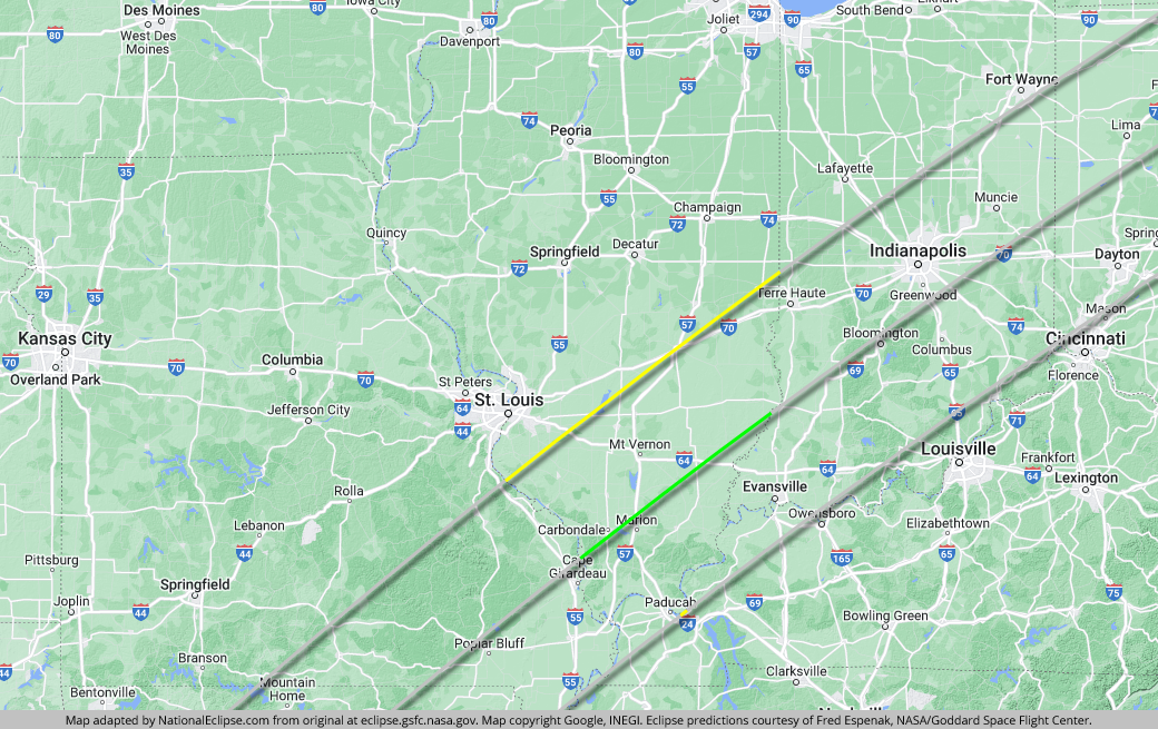
TOPFor the map below, the yellow lines outline the limits of the path of totality in Illinois. The green middle line represents the eclipse centerline, where totality lasts the longest in Illinois. The grey lines show the path of totality entering and exiting Illinois. To experience the total phase of the eclipse in Illinois, you must be within the yellow lines. The closer you are to the green centerline, the longer totality will last. Areas outside the path of totality will get a partial solar eclipse only.
(hover or tap to see points of interest in Illinois)
| City | Totality Start | Duration* |
|---|---|---|
| Tamms | 1:58:48 PM CDT | 3:50 |
| Chester | 1:58:55 PM CDT | 3:25 |
| Alto Pass | 1:58:57 PM CDT | 4:09 |
| Cairo | 1:59:03 PM CDT | 3:07 |
| Murphysboro | 1:59:09 PM CDT | 4:06 |
| Makanda | 1:59:10 PM CDT | 4:08 |
| Carbondale | 1:59:16 PM CDT | 4:08 |
| Marion | 1:59:44 PM CDT | 4:07 |
| Benton | 2:00:03 PM CDT | 4:06 |
| Metropolis | 2:00:11 PM CDT | 2:33 |
| Harrisburg | 2:00:27 PM CDT | 3:53 |
| Mount Vernon | 2:00:35 PM CDT | 3:45 |
| Golconda | 2:00:39 PM CDT | 2:51 |
| McLeansboro | 2:00:43 PM CDT | 4:07 |
| Bluford | 2:00:46 PM CDT | 3:53 |
| Centralia | 2:00:58 PM CDT | 2:44 |
| Mill Shoals | 2:01:11 PM CDT | 4:07 |
| Fairfield | 2:01:19 PM CDT | 4:03 |
| Salem | 2:01:20 PM CDT | 2:47 |
| Carmi | 2:01:21 PM CDT | 4:01 |
| Albion | 2:01:45 PM CDT | 4:06 |
| Kinmundy | 2:01:51 PM CDT | 2:21 |
| Olney | 2:02:12 PM CDT | 3:50 |
| Mount Carmel | 2:02:16 PM CDT | 4:03 |
| Effingham | 2:03:26 PM CDT | 0:49 |
| Marshall | 2:04:04 PM CDT | 2:35 |
| Paris | 2:05:14 PM CDT | 0:41 |
* "Duration" refers to the duration of totality and is expressed in minutes and seconds
TOP