(This is an archived page about the total solar eclipse that occurred on April 8, 2024. For information on future eclipses, please see our Upcoming Eclipse Maps page.)
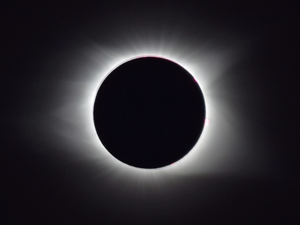 On April 8, 2024, a total solar eclipse will occur in Terre Haute, Indiana. Terre Haute, which has cleverly taglined their eclipse celebration as "A Total Eclipse of the Haute," is located on the western side of the eclipse path but still far enough inside for totality durations to surpass the 3-minute mark in some areas of the city. In the downtown area, Terre Haute will get about 2 minutes and 57 seconds of darkness. Below, we've provided key details about the eclipse in Terre Haute for locals and visitors planning on viewing the eclipse from that city.
| Start of Partial Eclipse | 1:48:17 PM EDT |
| Start of Total Eclipse | 3:04:23 PM EDT |
| Maximum Eclipse | 3:05:51 PM EDT |
| End of Total Eclipse | 3:07:20 PM EDT |
| End of Partial Eclipse | 4:21:30 PM EDT |
| Duration of Totality | 2 min, 57 sec |
| Alt / Azi at Maximum | +54.0° / 212.6° |
Eclipse data courtesy of Fred Espenak, NASA/Goddard Space Flight Center, from eclipse.gsfc.nasa.gov. Note that this data is approximate and doesn't take into account variations in lunar limb geography.
TOP| Year | Low | High | Sky* |
|---|---|---|---|
| 2023 | 36° F | 64° F | Sun |
| 2022 | 37° F | 46° F | Sun & Clouds |
| 2021 | 57° F | 68° F | Sun & Clouds |
| 2020 | 63° F | 82° F | Sun |
| 2019 | 55° F | 73° F | Sun |
* "Sky" refers to the general sky conditions that were observed for the indicated year at or near the time of day that totality will occur locally during the 2024 eclipse. It's recommended that eclipse chasers plan to stay mobile in the event that poor weather threatens visibility on April 8, 2024.
TOP
CURRENT WEATHER IN TERRE HAUTE
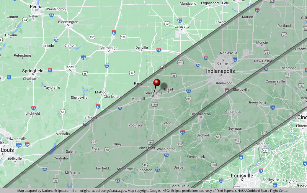
For an interactive map of the path of totality in Terre Haute, use the interactive Google eclipse maps developed by Xavier Jubier.
TOP(click or tap on any column header to re-sort)
| Location | Totality Start | Duration* |
|---|---|---|
| Fowler Park | 3:04:04 PM EDT | 3:25 |
| Griffin Bike Park | 3:04:06 PM EDT | 3:25 |
| Terre Haute Action Track | 3:04:15 PM EDT | 3:05 |
| CANDLES Holocaust Museum and Education Center | 3:04:20 PM EDT | 3:00 |
| Indiana Theatre | 3:04:23 PM EDT | 2:57 |
| Swope Art Museum | 3:04:23 PM EDT | 2:57 |
| Terre Haute Children's Museum | 3:04:23 PM EDT | 2:57 |
| Veterans Memorial Museum of Terre Haute | 3:04:23 PM EDT | 2:57 |
| Vigo County Courthouse | 3:04:23 PM EDT | 2:56 |
| Vigo County History Center | 3:04:23 PM EDT | 2:57 |
| Deming Park | 3:04:24 PM EDT | 3:03 |
| Eugene V. Debs Museum | 3:04:24 PM EDT | 2:56 |
| Hulman Center | 3:04:24 PM EDT | 2:57 |
| Indiana State University | 3:04:24 PM EDT | 2:55 |
| Terre Haute Masonic Temple | 3:04:24 PM EDT | 2:56 |
| Dobbs Memorial Park | 3:04:25 PM EDT | 3:06 |
| Memorial Stadium | 3:04:26 PM EDT | 3:00 |
| Wabash Valley Railroad Museum | 3:04:27 PM EDT | 2:54 |
| Hawthorn Park | 3:04:30 PM EDT | 3:01 |
* "Duration" refers to the duration of totality and is expressed in minutes and seconds
TOP