(This is an archived page about the annular solar eclipse that occurred on October 14, 2023. For information on future eclipses, please see our Upcoming Eclipse Maps page.)
On October 14, 2023, an annular, or "ring of fire," solar eclipse will occur along a narrow path of annularity in Utah. To experience the annular, or "ring of fire," phase of the eclipse, you must be located within this path, with the duration of annularity lasting the longest at the centerline. But where along the path should you plan to go? Below, we've outlined some of the unique features, landmarks, and viewing options along the path of annularity for Utah. We've also provided a detailed map of the path of annularity in Utah as well as annularity start times and durations for Utah cities that are located inside the path of annularity on October 14, 2023.
Remember that you must use special eclipse safety glasses or viewers at all times during an annular, or "ring of fire," solar eclipse. The NationalEclipse.com Eclipse Store offers a wide variety of certified safe eclipse glasses and viewers.
Note that times and durations can vary widely even within the same city and some cities are located only partially within the path of annularity. All times and durations noted on this page are only representative samples and should be used for general comparison purposes only.
To avoid confusion, note that references made below to the "western" and "eastern" limits or lines of the eclipse refer respectively to the left/bottom and right/top edges of the eclipse path as it gradually changes its direction from east to south as it travels across the U.S.
The centerline of the eclipse enters Utah at approximately 9:08am MDT, with annularity beginning in that location at about 10:24am MDT.
As it enters Utah, the eclipse track continues its journey through the arid multi-state Great Basin, where the chances for cloud-free skies should be relatively favorable. Farther ahead, the path of annularity crosses over Dixie National Forest, Fishlake National Forest, and Manti-La Sal National Forest. These forested areas will make for scenic eclipse viewing, but remember that the Sun is still only about 30 degrees above the horizon at this point. If you'll see the eclipse from any of these areas, make sure to position yourself where trees and terrain won't be in the way. Remember, also, that higher elevations means a greater chance for clouds.
The eclipse misses any cities of significant population in Utah, never crossing a town with a population of at least 10,000 people. The most populated town over which the eclipse travels in Utah is probably Richfield, where annularity will last for about 4 minutes and 37 seconds in the middle of town, a very generous duration for this eclipse. Richfield is located on Interstate 70, which enters the path from the east and crosses the centerline before terminating its route when it meets up with Interstate 15. I-15 crosses the entire width of the eclipse path, linking Salt Lake City from the north and Las Vegas from the south. You should be able to reach the path from Vegas in under three hours while a trip from Salt Lake will require only about half that time. Both cities, with their extensive lodging options, can serve as basecamps.
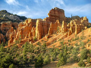
Beyond the forests, the eclipse enters that region of southern Utah known for its plethora of natural wonders. Among the "Mighty 5" national parks in Utah, the path of annularity crosses over three of them: Bryce Canyon National Park, Capitol Reef National Park, and Canyonlands National Park. And the other two—Zion National Park and Arches National Park—are located close by on the western and eastern flanks of the eclipse path, respectively. If all that wasn't enough, the eclipse path also crosses over Grand Staircase-Escalante National Monument, Glen Canyon National Recreation Area, and Natural Bridges National Monument. Needless to say, this entire region of southern Utah promises to offer some of the most spectacular natural backdrops for an eclipse viewing. Plus, the chances are high that the weather will cooperate here.
No description of southern Utah would be complete without a mention of the Four Corners Monument, which the eclipse crosses over. As the only location in the United States where four states meet, the monument placed at this exact quadripoint where the corners of Arizona, Colorado, New Mexico, and Utah come together is a popular tourist attraction. There's not much else around the monument itself, and it will likely be a popular viewing site on eclipse day, so a visit to the monument might best be saved for the days before or after the eclipse to avoid crowds.
The centerline of the eclipse exits the state at approximately 12:02pm MDT, with annularity coming to an end in that location at about 10:34am MDT. From the Nevada-Utah border to the Utah-Arizona border, the Moon's shadow travels approximately 305 miles along the centerline in about 5 minutes and 49 seconds at an average speed of 3,146 miles per hour.
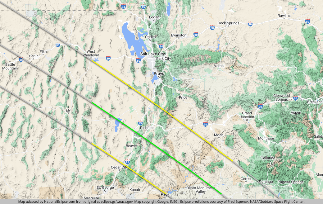
TOPFor the map below, the yellow lines outline the limits of the path of annularity in Utah. The green middle line represents the eclipse centerline, where the annular, or "ring of fire," phase lasts the longest in Utah. The grey lines show the path of annularity entering and exiting Utah. To experience the annular, or "ring of fire," phase of the eclipse in Utah, you must be within the yellow lines. The closer you are to the green centerline, the longer annularity will last. Areas outside the path of annularity will get a non-annular partial solar eclipse only.
(hover or tap to see points of interest in Utah)
| City | Annularity Start | Duration* |
|---|---|---|
| Gandy | 10:24:16 AM MDT | 4:43 |
| Partoun | 10:24:20 AM MDT | 4:39 |
| Ibapah | 10:24:23 AM MDT | 4:10 |
| Trout Creek | 10:24:25 AM MDT | 4:36 |
| Eskdale | 10:24:32 AM MDT | 4:27 |
| Garrison | 10:24:43 AM MDT | 4:02 |
| Black Rock | 10:25:34 AM MDT | 4:37 |
| Frisco | 10:25:46 AM MDT | 3:48 |
| Milford | 10:25:56 AM MDT | 4:01 |
| Delta | 10:26:01 AM MDT | 4:04 |
| Fillmore | 10:26:09 AM MDT | 4:33 |
| Beaver | 10:26:16 AM MDT | 4:13 |
| Richfield | 10:26:27 AM MDT | 4:37 |
| Salina | 10:26:53 AM MDT | 4:05 |
| Loa | 10:27:00 AM MDT | 4:43 |
| Panguitch | 10:27:15 AM MDT | 3:03 |
| Torrey | 10:27:17 AM MDT | 4:43 |
| Boulder | 10:27:26 AM MDT | 4:41 |
| Escalante | 10:27:30 AM MDT | 4:21 |
| Parowan | 10:27:32 AM MDT | 1:37 |
| Bryce | 10:27:35 AM MDT | 3:04 |
| Tropic | 10:27:43 AM MDT | 3:02 |
| Caineville | 10:27:50 AM MDT | 4:25 |
| Cannonville | 10:27:53 AM MDT | 2:48 |
| Manti | 10:27:57 AM MDT | 2:10 |
| Emery | 10:28:04 AM MDT | 3:00 |
| Ticaboo | 10:28:18 AM MDT | 4:47 |
| Hanksville | 10:28:23 AM MDT | 3:57 |
| Hite | 10:28:38 AM MDT | 4:36 |
| Ephraim | 10:28:48 AM MDT | 0:31 |
| Fry Canyon | 10:28:58 AM MDT | 4:41 |
| Navajo Mountain | 10:29:07 AM MDT | 3:34 |
| Oljato-Monument Valley | 10:29:22 AM MDT | 4:26 |
| Mexican Hat | 10:29:29 AM MDT | 4:47 |
| Bluff | 10:29:49 AM MDT | 4:42 |
| Blanding | 10:30:03 AM MDT | 4:02 |
| Monticello | 10:30:44 AM MDT | 2:43 |
* "Duration" refers to the duration of annularity and is expressed in minutes and seconds
TOP