(This is an archived page about the annular solar eclipse that occurred on October 14, 2023. For information on future eclipses, please see our Upcoming Eclipse Maps page.)
On October 14, 2023, an annular, or "ring of fire," solar eclipse will occur along a narrow path of annularity in Arizona. To experience the annular, or "ring of fire," phase of the eclipse, you must be located within this path, with the duration of annularity lasting the longest at the centerline. But where along the path should you plan to go? Below, we've outlined some of the unique features, landmarks, and viewing options along the path of annularity for Arizona. We've also provided a detailed map of the path of annularity in Arizona as well as annularity start times and durations for Arizona cities that are located inside the path of annularity on October 14, 2023.
Remember that you must use special eclipse safety glasses or viewers at all times during an annular, or "ring of fire," solar eclipse. The NationalEclipse.com Eclipse Store offers a wide variety of certified safe eclipse glasses and viewers.
Note that times and durations can vary widely even within the same city and some cities are located only partially within the path of annularity. All times and durations noted on this page are only representative samples and should be used for general comparison purposes only.
To avoid confusion, note that references made below to the "western" and "eastern" limits or lines of the eclipse refer respectively to the left/bottom and right/top edges of the eclipse path as it gradually changes its direction from east to south as it travels across the U.S.
The centerline of the eclipse enters Arizona at approximately 9:10am MDT, with annularity beginning in that location at about 10:30am MDT.
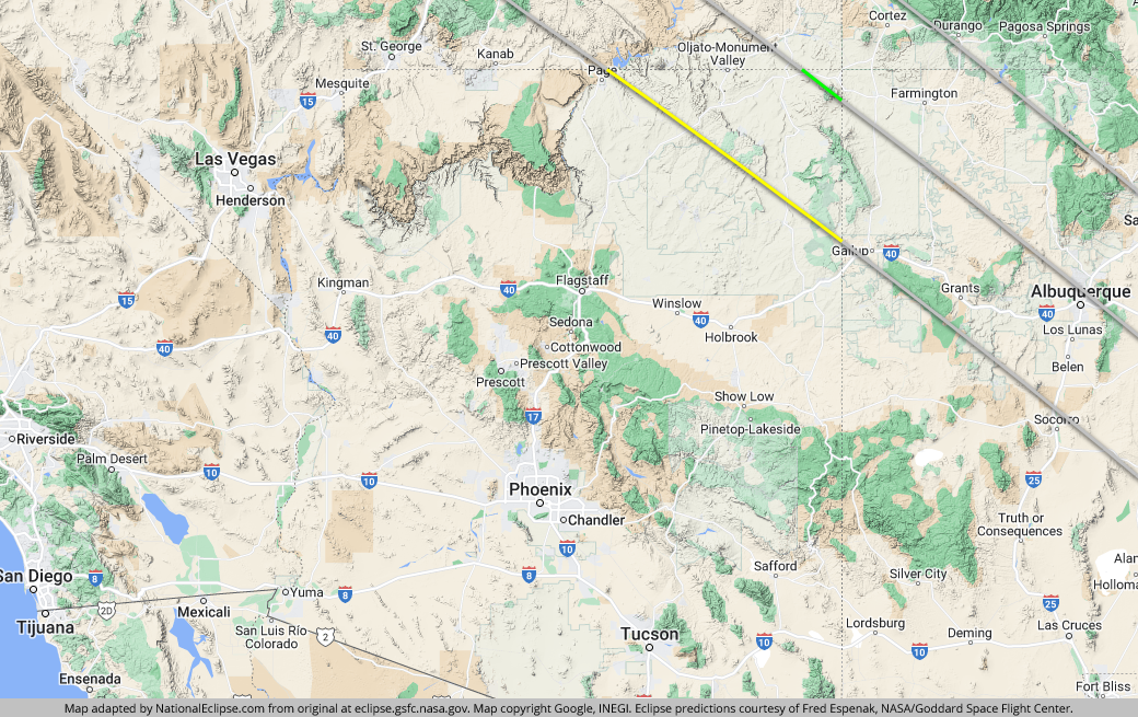
Only the extreme northeastern corner of Arizona is captured inside the eclipse path. Although the eastern line of the eclipse misses the state completely, the centerline does make an appearance, but it doesn't stick around for long. All told, the centerline races across a mere 28 miles of the high Arizona desert.
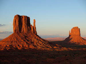
In Arizona, almost the entire eclipse path belongs to the Navajo Nation, offering visitors a variety of historical and cultural attractions and experiences. Along the Utah-Arizona border, the eclipse crosses over the sandstone buttes of the world famous Monument Valley area, most easily seen from U.S. Route 163, and the already-mentioned Four Corners Monument, where the state lines of Arizona, Colorado, New Mexico, and Utah come together.
Since this is sparsely populated Navajo land, it's not surprising that the eclipse path never crosses any large towns or cities here, certainly none with a population of more than 10,000 people. The most populated town over which the eclipse travels in Arizona is probably Kayenta—population about 5,000—where annularity will last for about 3 minutes and 39 seconds in the center of town.
By this point, the eclipse path has made the transition from the high desert of the Great Basin to the high desert of the Colorado Plateau, where the chances of cloudless skies on eclipse day are even better. What's more, the Grand Canyon is located only a day trip to the west. For travelers who want to combine an eclipse viewing expedition in Navajo country with a trip to one of the world's most famous natural wonders, Arizona is a great choice.
TOPFor the map below, the yellow line outlines the limits of the path of annularity in Arizona. The green middle line represents the eclipse centerline, where the annular, or "ring of fire," phase lasts the longest in Arizona. The grey lines show the path of annularity entering and exiting Arizona (the eastern line of the path doesn't enter Arizona). To experience the annular, or "ring of fire," phase of the eclipse in Arizona, you must be within the yellow line. The closer you are to the green centerline, the longer annularity will last. Areas outside the path of annularity will get a non-annular partial solar eclipse only.
(hover or tap to see points of interest in Arizona)
| City | Annularity Start | Duration* |
|---|---|---|
| Kayenta | 10:29:50 AM MDT | 3:39 |
| Tsegi | 10:30:05 AM MDT | 2:51 |
| Red Mesa | 10:30:07 AM MDT | 4:48 |
| Teec Nos Pos | 10:30:30 AM MDT | 4:46 |
| Rough Rock | 10:30:38 AM MDT | 3:17 |
| Many Farms | 10:30:45 AM MDT | 3:41 |
| Shonto | 10:30:47 AM MDT | 0:59 |
| Tsaile | 10:30:58 AM MDT | 4:14 |
| Chinle | 10:31:17 AM MDT | 2:59 |
| Fort Defiance | 10:32:29 AM MDT | 2:13 |
| Window Rock | 10:32:47 AM MDT | 1:45 |
* "Duration" refers to the duration of annularity and is expressed in minutes and seconds
TOP