On July 22, 2028, a total solar eclipse will trace a narrow path of totality across Australia and New Zealand. To experience the total phase of the eclipse, or "totality," you must be located within this narrow path of totality, with the duration of totality lasting the longest at the centerline. But where along the path should you plan to go? Below, we've outlined some of the unique features, landmarks, and viewing options along the path of totality.
Remember that you must use special eclipse safety glasses or viewers at all times during the partial phases of a total solar eclipse. The NationalEclipse.com Eclipse Store offers a wide variety of certified safe eclipse glasses and viewers.
Note that times and durations can vary widely even within the same city and some cities are located only partially within the path of totality. All times and durations noted on this page are only representative samples and should be used for general comparison purposes only. To determine the precise start time, end time, and duration of totality for your exact location on eclipse day, use the interactive eclipse maps developed by Xavier Jubier.
Note that the eclipse path gradually changes its direction from east to south as it travels across the planet. To avoid confusion, note that references made below to the "northern" or "eastern" limits or lines of the eclipse refer to the top/right edge of the path and references made to the "southern" or "western" limits or lines of the eclipse refer to the bottom/left edge of the path.
The total solar eclipse of July 22, 2028, begins at sunrise in the Indian Ocean about halfway between Africa and Australia. Coming less than a year after a 6-minute eclipse in northern Africa, the 2028 eclipse represents another chance to experience a spectacularly long duration of totality. When it reaches its point of greatest duration in western Australia, totality will last for over 5 minutes. But before it gets anywhere near the Australian continent, the eclipse shadow path first makes landfall about 2,000 miles away at a couple of tiny Australian island territories. The approximately 600 people of the Cocos (Keeling) Islands and 1,700 people of Christmas Island will be the first humans to witness a land-based totality on July 22.
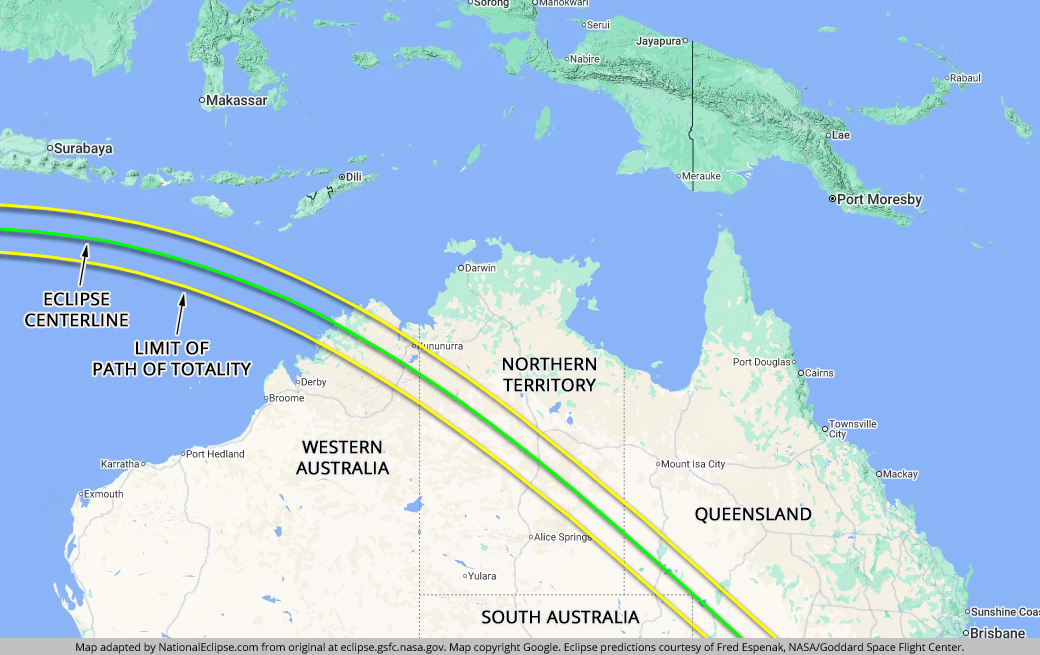
When it does reach Australia, the eclipse touches down on the top of the northern coast of the state of Western Australia. This is known as the Kimberley region of Western Australia, a remote and sparsely populated wilderness area. The population of the entire region is only about 34,000. But it's here in the Kimberley where the eclipse reaches its "point of greatest duration" on the centerline. At no other place will the total phase of the eclipse last longer than it will here when totality lingers for an amazing 5 minutes and 10 seconds. For any total eclipse, the point of greatest duration is also the eclipse "tipping point," with the duration increasing along the centerline up until that point and then decreasing beyond. Therefore, from here on out, the duration on the centerline will gradually decrease from its high point, but it stays above the 3-minute mark until leaving Australia.
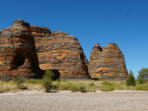
When the eclipse reaches the eastern side of the Kimberley, along the border with Australia's Northern Territory, it reaches the only town along its path thus far with a population above 1,000 people. Kununurra, population about 5,500, is located relatively close to the northern edge of the eclipse path, resulting in a duration of totality of about 2 minutes and 50 seconds at around 10:59am local time. The Great Northern Highway runs from the southern edge of the eclipse path in Western Australia, crosses the centerline, and then links up with the east-west Victoria Highway, which runs through Kununurra, near the northern edge of the path. On the south side of the eclipse path is Purnululu National Park with its interesting, but difficult to access with standard transportation, beehive-shaped "Bungle Bungle" formations.

The eclipse next passes into the Northern Territory as it continues its trek across the incredibly vast Australian Outback. Here the eclipse path tracks across miles and miles of huge cattle ranches and remote aboriginal lands. There are few paved roads in the region. The most prominent road is the Stuart Highway, which bisects the entire path of totality. If you were hoping to witness totality at the famous Ayers Rock, or Uluru, that won't be possible. The massive red sandstone monolith is located far south of the path of totality and will experience an 85 percent partial solar eclipse only. However, easily accessible from the Stuart Highway, and almost directly on the centerline, is the Karlu Karlu/Devils Marbles Conservation Reserve with its namesake gigantic balancing granite boulders. The largest town along the eclipse path in the Northern Territory is Tennant Creek, population about 3,500, a historic gold-mining town located along the Stuart Highway. Tennant Creek is situated fairly close to the edge of the eclipse path, but still far enough inside for a duration of totality lasting for about 3 minutes and 21 seconds.
Ironically, the most remote and isolated stretch of the eclipse path in Australia—encompassing Western Australia and the Northern Territory—is also the stretch with the best prospects of sunny skies on eclipse day. Remember that July is winter in the Southern Hemisphere, but northern Australia stays very warm and dry during these months. The problem, of course, is that this part of the country is very far removed from population centers with many unsealed Outback tracks that may require a high-clearance four-wheel drive vehicle.
After the eclipse leaves the Northern Territory, it passes into the state of Queensland and more of the seemingly endless red-tinted Outback that came before. Eyre Developmental Road runs from the southern edge of the path, crosses the centerline, and then continues as Diamantina Developmental Road all the way to the northern edge of the path. As it makes its way through southwestern Queensland, the southern half of the eclipse path crosses into the northeast corner of the state of South Australia, capturing a relatively small triangle of land inside the totality zone. The vertex of the triangle's right angle reaches almost all the way to the centerline. A short distance later, the southern side of the path exits South Australia and the full width of the path continues its southeasterly journey through Queensland. In this extremely sparsely populated part of the state, the eclipse path never crosses any town with a population greater than just a few hundred people.
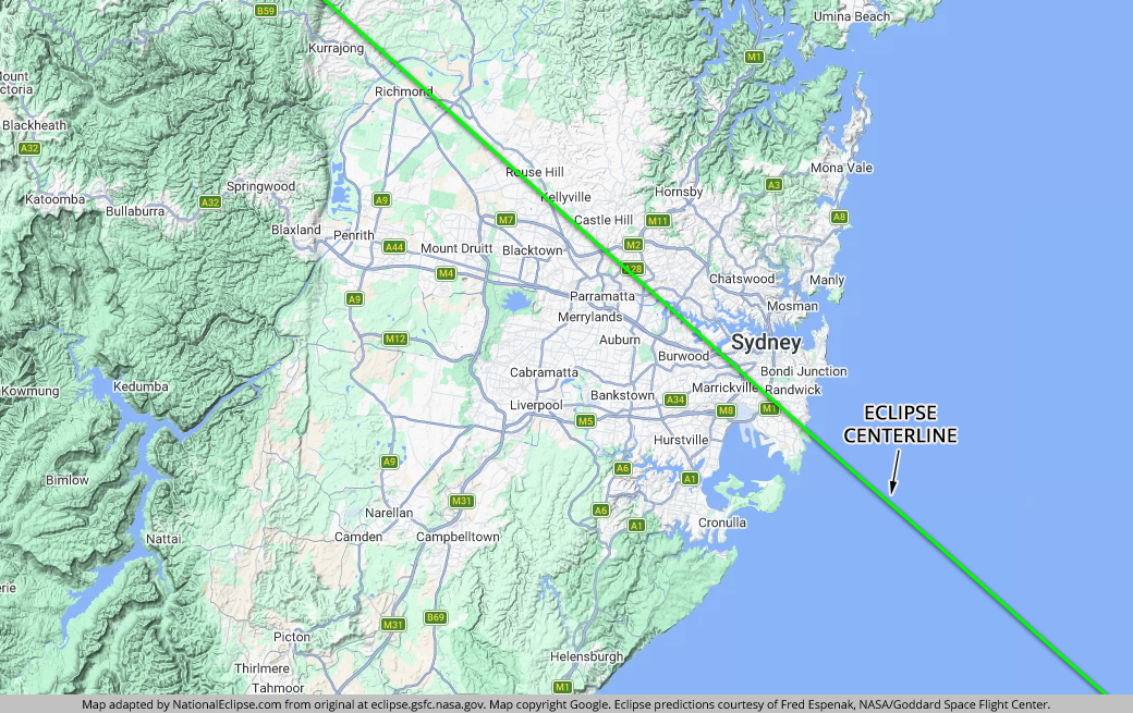
Finally, the path of totality slips into New South Wales. NSW is certainly where most people will witness totality down under. In fact, the path makes a direct beeline for Australia's largest city—but more on that later. When it first enters New South Wales, the eclipse path continues its long journey through Australia's Outback rangelands. Although it's not as remote here as in Queensland, it's still remote, although there are more paved roads crisscrossing the area here than earlier. The Mitchell Highway comes down from the northern/eastern edge of the path in Queensland, crosses the centerline, and then runs roughly parallel to the centerline along the middle of the path's southern/western half until it reaches more populated areas. The Kamilaroi Highway comes in from the east and meets up with the Mitchell Highway a short distance beyond the centerline. The path crosses over the small town of Bourke, population about 2,300 and very close to the centerline, where totality will last for about 4 minutes and 6 seconds.
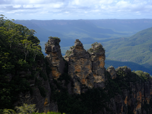
When the eclipse reaches Dubbo, population about 43,500, it's the first time since touching down in Australia that the path of totality will cross over any town or city with a significant population. Although Dubbo would be considered only a small city by most standards, it's a virtual metropolis compared to the tiny Outback towns encountered along the path up to this point. In Dubbo, totality will last for about 3 minutes and 51 seconds. The Newell Highway bisects the entire path of totality, passing through Dubbo. Beyond Dubbo, the eclipse crosses over the Blue Mountains, part of Australia's Great Dividing Range. This area contains several national parks, including the popular Blue Mountains National Park. Some of the larger towns in the region include Mudgee, Orange, and Bathurst. In Mudgee, totality will last for about 3 minutes and 54 seconds. In Orange and Bathurst, about 2:11 and 3:03, respectively.
As for weather, the chances for cloudy skies along the eclipse path in July are higher in Queensland and New South Wales than in Western Australia and the Northern Territory, but it's a small increase. When the path enters the higher elevations around Dubbo and the mountains beyond, however, the possibility of clouds increases more dramatically. Still, despite the fact that high elevations are typically known to promote the formation of clouds, the overall dryness of the winter months keeps the outlook more favorable here than it otherwise would be.

As the eclipse path descends down from the mountains, it enters the suburbs and then the city itself of Sydney. A city can't be any better positioned for a total solar eclipse than Sydney is on July 22, 2028. The centerline of the eclipse cuts directly across the heart of the city, slicing through about four miles south of the Sydney Opera House. If you're standing at that iconic location at exactly 1:59pm local time, you'll see darkness descend on Sydney Harbour for about 3 minutes and 48 seconds. It's the irony of ironies that the eclipse crosses over an entire continent without encountering much more than arid Outback and remote bushland, and then passes directly over one of the world's major cities.
The weather situation in Sydney is a little more complicated than what came before. Both the mountains to the west and the ocean to the east can influence the kind of weather that Sydney might experience in July. In other words, clouds can be present. The eclipse weather forecasting experts report average July cloud cover for Sydney at about 30 to 40 percent, so the outlook really isn't all that bad. But considering that the vast majority of people who see totality in Australia will see it from Sydney, the stakes are much higher here than anywhere else. As with most eclipses, the best strategy in Sydney might be to stay mobile in the event that moving to another area of the city or surrounding suburbs might result in clearer skies.
After the eclipse leaves Sydney, it flies across the Tasman Sea for a date with Australia's neighbor to the southeast.
(hover or tap to see points of interest in Australia)
(hover or tap to see points of interest in Australia)
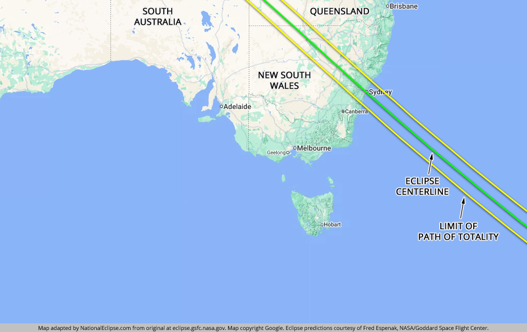
(hover or tap to see points of interest in Sydney)
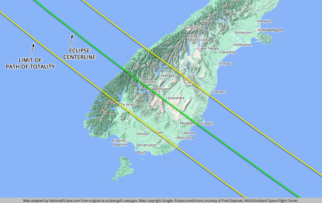
The 2028 eclipse arrives in New Zealand in the late afternoon when the Sun will be low on the horizon, traveling across the South Island of New Zealand, the less populous of the nation's two main islands. For a visitor, seeing totality in New Zealand will most likely require flying into Christchurch and then driving (or catching a connecting flight) south almost all the way to the end of the island to get inside the eclipse path. It will also mean finding a viewing site with a clear view toward the horizon.
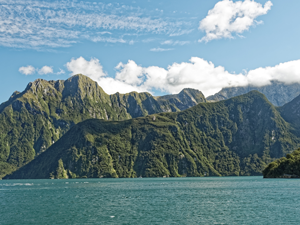
The path of totality first touches down in New Zealand along the rugged southwestern coast of the South Island, a wet alpine wilderness of towering granite peaks and huge glacial valleys. Although more travelers ultimately visit the North Island, the South Island boasts New Zealand's most famous tourist attraction—the incomparable Milford Sound. Despite its remote location, this glacially carved fiord receives up to a million visitors each year. Not only is this location beautiful, it's also located almost directly on the centerline. Needless to say, this will be a very popular place on July 22, 2028. In the town of Milford Sound itself, totality will last for about 2 minutes and 56 seconds at 4:14pm New Zealand time.
Further along, the path crosses over Queenstown, a major outdoor and adventure tourism center in New Zealand. Queenstown is also located almost directly on the eclipse centerline and will experience a totality duration of about 2 minutes and 55 seconds. About halfway between the centerline and the northern/eastern limit of the eclipse path is the resort town of Wānaka, with a duration of totality lasting for about 2 minutes and 26 seconds. Beyond the ultra-wet rainforests of the "Southern Alps," the eclipse path descends down into the semi-arid rolling hills and valleys of the central part of the southern end of the South Island. Some of the larger towns in this area are Cromwell and Alexandra, both fairly close to the centerline, where totality will last for about 2:50 and 2:53, respectively.
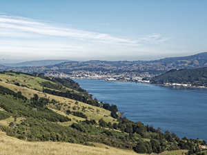
Finally, the last topographic transition occurs as the path moves into the eroded volcanic hills and coastal plains of the southeastern coast of the South Island. In all, the eclipse path travels less than 200 miles from coast to coast. By far, the largest city inside the path of totality in New Zealand is Dunedin, situated on the southeastern coast. It seems that almost all of the larger towns and cities inside the path in New Zealand just happen to be located close to the centerline, and Dunedin is no exception. The centerline passes directly through the city, with totality lasting for about 2 minutes and 51 seconds at 4:15pm local time.
The location and topography of New Zealand's South Island makes for a complex weather tableau. Clouds are very possible anywhere along the eclipse path in New Zealand, although prospects are a little more favorable on the northern/eastern side of the eclipse path from Wānaka down to the coast. Snow is possible at this time of year, especially in the mountains.
All things considered, including the potential difficulty of finding a clear sightline toward the lowering Sun, the diminished totality duration here near the end of the eclipse path, the relative remoteness of the South Island as compared to the North, and the very real possibility of cloudy skies, Australia is probably the better option for the 2028 eclipse. New Zealand will get another total solar eclipse in 2037, with a path of totality that crosses the North Island not far from Auckland, so if you don't mind delaying your trip to New Zealand for another nine years, there's another chance to see totality in the land of the Kiwis that might prove more convenient.
(hover or tap to see points of interest in New Zealand)